SkyPix

A digital photographic storybook of clouds, weather and water by Roger Edwards.

  • Home
  • Newest Posts
  • Galleries (Menu)
    • Aerial
    • All Hail
    • Burnscapes
    • Daytime Lightning
    • Floods
    • Fog and Mist
    • Gallery of Outflow
    • Hurricane Andrew
    • Mini Cloud Atlas
    • Night Lightning
    • Mostly Okie Winters
    • Panoramics
    • Sunsets and Sunrises
    • The Majestic Supercell
    • Tornadoes
    • Unusual Weather Damage
    • Visual Effects
    • Wall Cloud Wall
    • Water Works
  • About
  • F.A.Q.
  • Contact
'24 at the Tree Part 1

’24 at the Tree Part 1

2024-02-08 By Roger Edwards

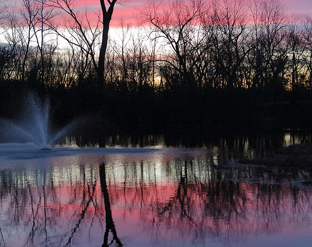
[Part 1 of 2.5] Sunrises here at the tree have been few this winter, thanks to a combination of lack of decent clouds, being asleep, or being at work.  However, on this day we got two distinct sunrises in one event, thanks to an intervening stage where distant clouds blocked the light.  Right before that, early dawn reds and pinks graced a fast-moving cirrus deck, while reflected from tranquil … [Read more...]

Filed Under: Sunsets and Sunrises, Water Works Tagged With: cirrus, clouds, forests, fountains, lakeshores, Norman, Oklahoma, reflectives, Sunrise Tree, sunrises, waterscapes, weather

Panhandle Sunset Supercell

Panhandle Sunset Supercell

2024-02-07 By Roger Edwards

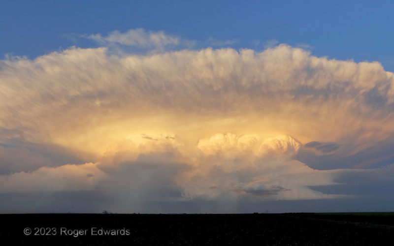
Without any obstructions to block a piece of the view, the southern Texas Panhandle's Llano Estacado offers sky views like few other places.  That's especially amazing when a splitting supercell rides off into the eastern sky at sunset, each member bearing a hail shaft while the updrafts and backsheared mammatus above bask in the warm light of the last rays.  Meanwhile, the indirect glow reflected … [Read more...]

Filed Under: Sunsets and Sunrises, The Majestic Supercell Tagged With: backshear, clouds, convection, Great Plains, mammatus, sunsets, supercells, Texas, Texas Panhandle, thunderstorms, Tulia, weather

Panhandle Slim

Panhandle Slim

2024-02-04 By Roger Edwards

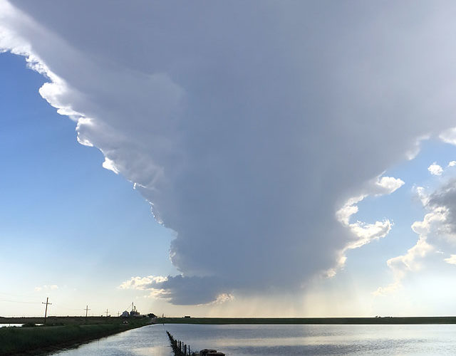
Backdropping a flooded field (that was definitely mosquito-infested!), a slender supercell updraft pumped seemingly disproportionately large mass into its elongated cumulonimbus anvil.  Meanwhile, to the north and unseen in this view, a young but much larger supercell cruised toward becoming a festival of fine structure.  Fortunately the supercells sucked up far more of the parasites than the … [Read more...]
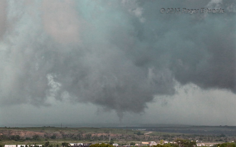
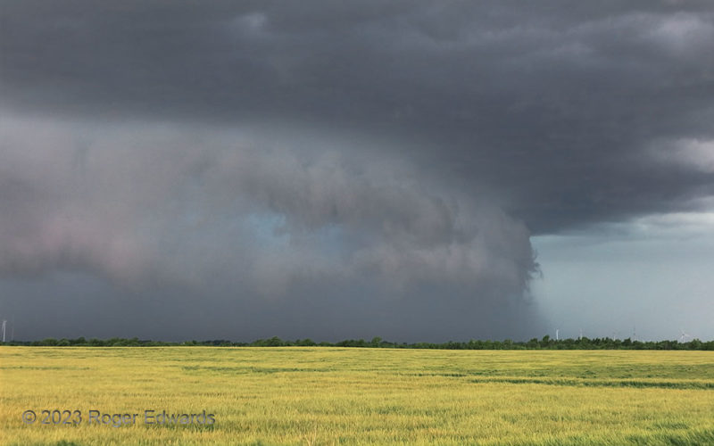
Filed Under: Mini Cloud Atlas, The Majestic Supercell Tagged With: clouds, convection, cumulonimbus, Great Plains, landscapes, storms, Summerfield, supercells, Texas, Texas Panhandle, thunderstorms, weather

Canadian Fifth

Canadian Fifth

2024-01-30 By Roger Edwards

After a small multivortex tornado spent a few minutes diving southward in an elongated mesocyclone or cyclonic-shear zone, the entire, merged Canadian storm complex started a major rain dump and surged eastward.  That process destroyed all the original shear zone, but not before this last, northern segment tightened up and pulled a "fast one" in the ragged remains of an updraft.  This brief, … [Read more...]

Filed Under: Tornadoes Tagged With: Canadian, clouds, convection, Great Plains, landscapes, supercells, Texas, Texas Panhandle, thunderstorms, tornado, wall clouds, weather

Northward Surge

Northward Surge

2024-01-28 By Roger Edwards

Northward-directed, rear-flank downdraft surge in a cyclonic supercell?  Yes, when the supercell is moving northward, as was this intense storm southwest of Oklahoma City (here seen several minutes before in a wide-angle view from the same location).  It reminded me a lot of a "Stormzilla" scene from the previous year in southern Kansas, also with a large RFD surge, but in a severe storm moving … [Read more...]
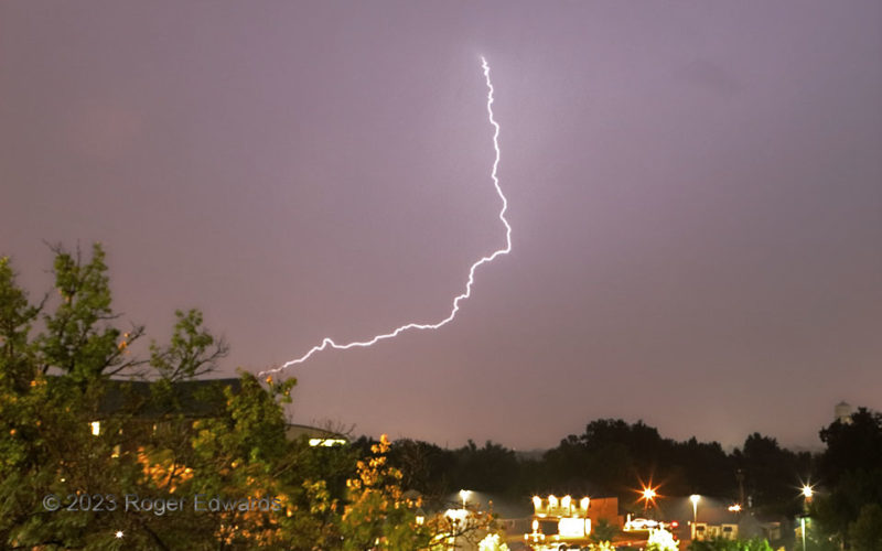
Filed Under: Gallery of Outflow Tagged With: clouds, convection, Great Plains, landscapes, Oklahoma, outflow, storms, supercells, thunderstorms, Tuttle, weather, wind farm

Spark in the Rain

Spark in the Rain

2024-01-26 By Roger Edwards

One lone, long spark sliced the city-lit, lightly rainy night sky, in the trailing precipitation area of a small, fast-moving thunderstorm cluster.  Discharges like this originate high in the cloud canopy, where ice crystals dominate the precip type, and charge still can build enough to connect through a few miles of wet air to the ground.  This one appears to hit the building at left, behind … [Read more...]

Filed Under: Night Lightning Tagged With: cityscapes, landscapes, lightning, nighttime, Norman, Oklahoma, storms, thunderstorms, University of Oklahoma, weather

  • « Previous Page
  • 1
  • …
  • 52
  • 53
  • 54
  • 55
  • 56
  • …
  • 413
  • Next Page »

About

Welcome to SkyPix, an online photo book of clouds, weather and water by Roger Edwards. As in a printed coffee-table book, every image has its own page with a unique story. After all, meaningful photography is much more than just picture-taking; it is visually rendering a moment in place and time from a perspective like none other. As a scientist and an artist, I hope my deep passion for the power and splendor of our skies and waters shines through in these pages. If you are a cloud and weather aficionado, outdoor enthusiast, outdoor or nature photographer, art lover, or anyone who craves learning, enjoy...

More

Further images from this photographer may be found at:
Roger Edwards Image of the Week
Roger Edwards Digital Galleries
Storms Observed Chase BLOG

Copyright © 2026 ROGER EDWARDS SKYPIX.PHOTOGRAPHY ALL RIGHTS RESERVED. · Design by INSOJOURN Design and Images · WordPress · Log in