SkyPix

A digital photographic storybook of clouds, weather and water by Roger Edwards.

  • Home
  • Newest Posts
  • Galleries (Menu)
    • Aerial
    • All Hail
    • Burnscapes
    • Daytime Lightning
    • Floods
    • Fog and Mist
    • Gallery of Outflow
    • Hurricane Andrew
    • Mini Cloud Atlas
    • Night Lightning
    • Mostly Okie Winters
    • Panoramics
    • Sunsets and Sunrises
    • The Majestic Supercell
    • Tornadoes
    • Unusual Weather Damage
    • Visual Effects
    • Wall Cloud Wall
    • Water Works
  • About
  • F.A.Q.
  • Contact

Tornadic Soon Signs

2026-09-08 By Roger Edwards

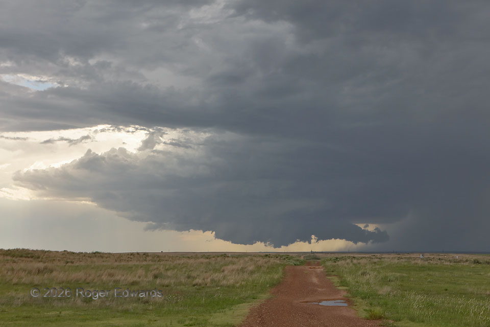
Tornadic Soon Signs
To no surprise of experienced storm observers, this supercell would produce a cone tornado soon, within the following 5-15 minutes.  Clues — some of which are visible here, others gleaned from observations afield — included:
* Storm persistence and growth for over an hour to this point,
* Continually stronger rightward (southward) motion component,
* A large ambient base area neither undercut by outflow nor experiencing precipitation cascade through the updraft,
* A strong but not too outflow-aggressive forward-flank core, to help with baroclinicity and vorticity on the vault side and feed…
* A thickening, somewhat convective downshear tail cloud that exhibited increasing horizontal and vertical motion,
* The formation of a large, low and increasingly rotating wall cloud beneath the broad and initially high ambient base, indicating falling pressure in and near a strengthening mesocyclone,
* Mesonet observations showing progressively higher dewpoints with similar temperatures (implying greater moisture and buoyancy) in its projected path.
All these made us more confident than usual in this supercell’s tornado potential.  We were repositioning slightly south to maintain view without interference from the likewise right-moving core, when the tornado formed, so I missed photographing its first few minutes while finding a suitable pulloff not blocked by higher terrain immediately in the way.

7 S Gate OK (25 Jun 26) Looking W
36.7469, -100.0583

Filed Under: The Majestic Supercell, Wall Cloud Wall Tagged With: convection, Gate, Great Plains, landscapes, Oklahoma, Oklahoma Panhandle, scud, storms, supercells, tail cloud, thunderstorms, vault, wall clouds, weather

Previous: Beaver County Cone

About

Welcome to SkyPix, an online photo book of clouds, weather and water by Roger Edwards. As in a printed coffee-table book, every image has its own page with a unique story. After all, meaningful photography is much more than just picture-taking; it is visually rendering a moment in place and time from a perspective like none other. As a scientist and an artist, I hope my deep passion for the power and splendor of our skies and waters shines through in these pages. If you are a cloud and weather aficionado, outdoor enthusiast, outdoor or nature photographer, art lover, or anyone who craves learning, enjoy...

More

Further images from this photographer may be found at:
Roger Edwards Image of the Week
Roger Edwards Digital Galleries
Storms Observed Chase BLOG

Copyright © 2026 ROGER EDWARDS SKYPIX.PHOTOGRAPHY ALL RIGHTS RESERVED. · Design by INSOJOURN Design and Images · WordPress · Log in