SkyPix

A digital photographic storybook of clouds, weather and water by Roger Edwards.

  • Home
  • Newest Posts
  • Galleries
    • Aerial
    • All Hail
    • Burnscapes
    • Daytime Lightning
    • Floods
    • Fog and Mist
    • Gallery of Outflow
    • Hurricane Andrew
    • Mini Cloud Atlas
    • Night Lightning
    • Mostly Okie Winters
    • Sunsets and Sunrises
    • The Majestic Supercell
    • Tornadoes
    • Unusual Weather Damage
    • Visual Effects
    • Wall Cloud Wall
    • Water Works
  • About
  • F.A.Q.
  • Contact

Wrap-Up with Spinups

2019-05-12 By Roger Edwards

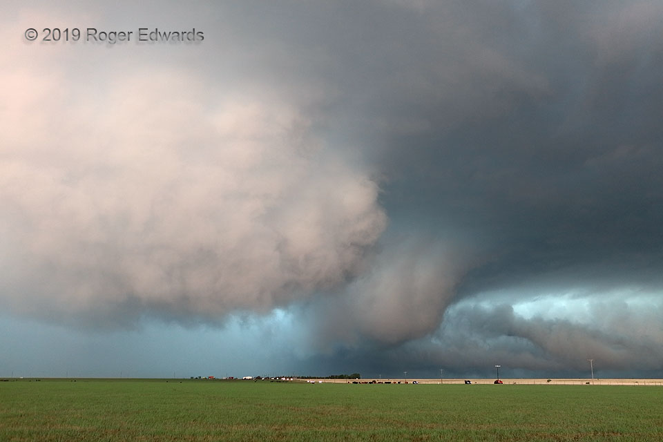
[Part 3 of 4] As the big Tulia-to-Wayside HP supercell churned northeastward, the somewhat conical, somewhat blocky, rapidly rotating wall cloud that had followed the HP rear-flank surge northward wrapped back into the larger circulation, tightened essentially to tornadic strength on its own merit, and ultimately merging with the original mesocyclone. The northern part of the surge now was represented by a similarly strangely illuminated, large, ragged area of lowered clouds at middle to left, with its own areas of concentrated cloud-base rotation. Meanwhile the tail-cloud features kept feeding into the backside of the broader mesocyclonic orbit with ferocious speed. This was a complex process with assorted vortices of multiple scales and velocities, very difficult to classify simply, that straddled the sometimes blurry line between mesocyclone and tornado! Wet fields prevented easy lofting of dust by these circulations, making precise visual tornado identification even more ambiguous. Very rapid cloud-base rotation and brief, wispy spinups were apparent under the central part of all this mess during this stage, and OU RaXPol radar parked a couple miles to my east (rear) affirmed at least two brief tornadoes, though they were very smudgy, low in contrast and difficult to make out with eyeballs. With the front edge of the bowing surge about to hit my location, I bailed east quickly… [Go to part 4]

4 WSW Vigo Park TX (7 May 19) Looking WNW
34.645, -101.5644

RADAR

Filed Under: The Majestic Supercell, Tornadoes, Wall Cloud Wall Tagged With: clouds, convection, Great Plains, storms, supercells, tail cloud, Texas, Texas Panhandle, thunderstorms, tornado, tornado cyclone, Vigo Park, wall clouds, weather

Previous: Tremendous HP Wrap-Up
Next: Entry Way to Storm

About

Welcome to SkyPix, an online photo book of clouds, weather and water by Roger Edwards. As in a printed coffee-table book, every image has its own page with a unique story. After all, meaningful photography is much more than just picture-taking; it is visually rendering a moment in place and time from a perspective like none other. As a scientist and an artist, I hope my deep passion for the power and splendor of our skies and waters shines through in these pages. If you are a cloud and weather aficionado, outdoor enthusiast, outdoor or nature photographer, art lover, or anyone who craves learning, enjoy...

More

Further images from this photographer may be found at:
Roger Edwards Image of the Week
Roger Edwards Digital Galleries
Storms Observed Chase BLOG

Copyright © 2025 ROGER EDWARDS SKYPIX.PHOTOGRAPHY ALL RIGHTS RESERVED. · Design by INSOJOURN Design and Images · WordPress · Log in