SkyPix

A digital photographic storybook of clouds, weather and water by Roger Edwards.

  • Home
  • Newest Posts
  • Galleries
    • Aerial
    • All Hail
    • Burnscapes
    • Daytime Lightning
    • Floods
    • Fog and Mist
    • Gallery of Outflow
    • Hurricane Andrew
    • Mini Cloud Atlas
    • Night Lightning
    • Mostly Okie Winters
    • Sunsets and Sunrises
    • The Majestic Supercell
    • Tornadoes
    • Unusual Weather Damage
    • Visual Effects
    • Wall Cloud Wall
    • Water Works
  • About
  • F.A.Q.
  • Contact

Whirling past Wapanucka, Part 1

2020-04-25 By Roger Edwards

Whirling past Wapanucka, Part 1 (tornado)

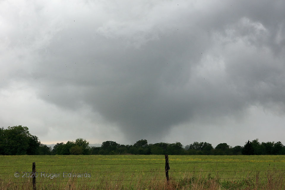
[Part 1 of 4]  Just a shade under four years earlier, I came home from a night shift, went to bed, and told my wife, Elke: “Wake me up if there’s a supercell within a couple counties of us, west of I-35”.  There was, she did, and after a quick look at satellite, surface chart and radar, I threw on clothes and bolted off.   While unable to get down the Interstate in time for the first of a tornadic storm’s production, I went southeast then south to witness the next, from a wildflower-laden clearing, directly in its eastward path.  I evacuated out of the way after starting to hear it, then watched the vortex cross the road with a roaring cascade of rain and debris not far to the north.  On this day, the very same basic story unfolded, albeit slightly farther from home.  Driving through driving rain at times, I had a sense of deja vu the whole way down, having lived this script before.  This tornado, emerging behind the rear-flank gust front from a smaller, more deeply occluded mesocyclone, was nowhere nearly as large or violent as the 2016 Sulphur wedge, and that’s a good thing!  The specks in this photo aren’t camera noise nor sensor dust; they’re real:  birds by the dozens, desperately trying to escape the oncoming menace by flying south, into the strengthening mesocyclonic wind.  I hope they all succeeded.  [Part 2]

1 N Wapanucka OK (22 Apr 20) Looking W
34.3961, -96.4246

RADAR


Filed Under: Tornadoes Tagged With: Bromide, clouds, convection, landscapes, Oklahoma, storms, supercells, thunderstorms, tornado, Wapanucka, weather, wildflowers

Previous: Panhandle Anticrepuscular Rays
Next: Needmore Rotation!

About

Welcome to SkyPix, an online photo book of clouds, weather and water by Roger Edwards. As in a printed coffee-table book, every image has its own page with a unique story. After all, meaningful photography is much more than just picture-taking; it is visually rendering a moment in place and time from a perspective like none other. As a scientist and an artist, I hope my deep passion for the power and splendor of our skies and waters shines through in these pages. If you are a cloud and weather aficionado, outdoor enthusiast, outdoor or nature photographer, art lover, or anyone who craves learning, enjoy...

More

Further images from this photographer may be found at:
Roger Edwards Image of the Week
Roger Edwards Digital Galleries
Storms Observed Chase BLOG

Copyright © 2025 ROGER EDWARDS SKYPIX.PHOTOGRAPHY ALL RIGHTS RESERVED. · Design by INSOJOURN Design and Images · WordPress · Log in