 Shortly before this circulation formed, the storm had the typically high, roughly textured, broad base of a young supercell on Colorado’s eastern High Plains, and was similar to many other storms I’ve seen in these parts. In about a 15-minute span, a scuddy wall cloud formed, tapering and lowering its ragged form while steadily spinning stronger. The cloud grew lower as air rose faster, thanks to a strengthening low-level mesocyclone, and the corresponding pressure drop. Tornadoes don’t “touch down” in a physical sense; that’s just a visual illusion. Instead, the air is rising in them as they form, and the pressure decrease lowers the cloud-condensation level. By this time, the lowermost, ragged, scuddy fingers rotated around their own axes and each other, as did swirling columns of dust just underneath. Because the process was gradual, never showing cloud condensation at ground level, and with dust discontinuously rising and/or more-weakly rotating before this, the precise moment of tornadogenesis was uncertain. What I knew for sure was that a tornado was underway here. This modest little multiple-vortex tornado lasted 2–3 minutes before weakening. I saw at least one more similar, briefer, lower-contrast spinup farther away, as the same mesocyclone retreated deeper into a road void. Then it all moved too far away for contrast sufficient to make out dust or debris at ground level. Though it got away from me, the “Yuma” supercell ultimately evolved into a structural feast that was well-documented by the TORUS field project in southwestern Nebraska. Meanwhile, another storm formed to the southwest and rode the outflow of this one, in visually spectacular fashion.
8 N Yuma CO (27 May 19) Looking NE
40.2417, -102.7183
RADAR
Shortly before this circulation formed, the storm had the typically high, roughly textured, broad base of a young supercell on Colorado’s eastern High Plains, and was similar to many other storms I’ve seen in these parts. In about a 15-minute span, a scuddy wall cloud formed, tapering and lowering its ragged form while steadily spinning stronger. The cloud grew lower as air rose faster, thanks to a strengthening low-level mesocyclone, and the corresponding pressure drop. Tornadoes don’t “touch down” in a physical sense; that’s just a visual illusion. Instead, the air is rising in them as they form, and the pressure decrease lowers the cloud-condensation level. By this time, the lowermost, ragged, scuddy fingers rotated around their own axes and each other, as did swirling columns of dust just underneath. Because the process was gradual, never showing cloud condensation at ground level, and with dust discontinuously rising and/or more-weakly rotating before this, the precise moment of tornadogenesis was uncertain. What I knew for sure was that a tornado was underway here. This modest little multiple-vortex tornado lasted 2–3 minutes before weakening. I saw at least one more similar, briefer, lower-contrast spinup farther away, as the same mesocyclone retreated deeper into a road void. Then it all moved too far away for contrast sufficient to make out dust or debris at ground level. Though it got away from me, the “Yuma” supercell ultimately evolved into a structural feast that was well-documented by the TORUS field project in southwestern Nebraska. Meanwhile, another storm formed to the southwest and rode the outflow of this one, in visually spectacular fashion.
8 N Yuma CO (27 May 19) Looking NE
40.2417, -102.7183
RADARWeak Multivortex Tornado
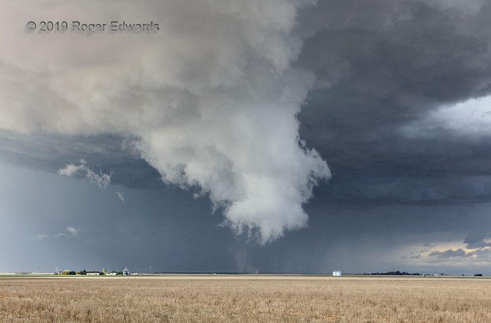
Shortly before this circulation formed, the storm had the typically high, roughly textured, broad base of a young supercell on Colorado’s eastern High Plains, and was similar to many other storms I’ve seen in these parts. In about a 15-minute span, a scuddy wall cloud formed, tapering and lowering its ragged form while steadily spinning stronger. The cloud grew lower as air rose faster, thanks to a strengthening low-level mesocyclone, and the corresponding pressure drop. Tornadoes don’t “touch down” in a physical sense; that’s just a visual illusion. Instead, the air is rising in them as they form, and the pressure decrease lowers the cloud-condensation level. By this time, the lowermost, ragged, scuddy fingers rotated around their own axes and each other, as did swirling columns of dust just underneath. Because the process was gradual, never showing cloud condensation at ground level, and with dust discontinuously rising and/or more-weakly rotating before this, the precise moment of tornadogenesis was uncertain. What I knew for sure was that a tornado was underway here. This modest little multiple-vortex tornado lasted 2–3 minutes before weakening. I saw at least one more similar, briefer, lower-contrast spinup farther away, as the same mesocyclone retreated deeper into a road void. Then it all moved too far away for contrast sufficient to make out dust or debris at ground level. Though it got away from me, the “Yuma” supercell ultimately evolved into a structural feast that was well-documented by the TORUS field project in southwestern Nebraska. Meanwhile, another storm formed to the southwest and rode the outflow of this one, in visually spectacular fashion.
8 N Yuma CO (27 May 19) Looking NE
40.2417, -102.7183
RADAR