 A hard-right-moving supercell fired off the dryline in the Texas Panhandle and churned southward (right to left) toward and across eastern Amarillo. Before it got there, several high-based wall clouds appeared, related to mesocyclone cycles. Here, a newer, tiered wall cloud appears on the left (south) side, ahead of an older, ragged one with a deep occlusion at right rear. At far right, that “sagging water balloon” look is for a good reason: a microburst plunging down. Like that water balloon, a microburst is a very dense fluid compared to surroundings, except there’s no rubber skin to stop it. Only the ground will. Upon slamming into the surface, the current of heavy rain and cold air (probably including hail in this case) has nowhere to go but outward, with a horizontal, expanding-donut-shaped logrolling action that we weather scientists call a “toroid”. So it does, producing a ring of intense, usually severe and damaging wind that weakens with distance from the source, akin to a blast wave. The damage from microbursts can resemble that of an airburst bomb, with outward-divergent “starburst” patterns.
6 NE Amarillo TX (8 Jun 17) Looking WNW
35.3175, -101.6185
A hard-right-moving supercell fired off the dryline in the Texas Panhandle and churned southward (right to left) toward and across eastern Amarillo. Before it got there, several high-based wall clouds appeared, related to mesocyclone cycles. Here, a newer, tiered wall cloud appears on the left (south) side, ahead of an older, ragged one with a deep occlusion at right rear. At far right, that “sagging water balloon” look is for a good reason: a microburst plunging down. Like that water balloon, a microburst is a very dense fluid compared to surroundings, except there’s no rubber skin to stop it. Only the ground will. Upon slamming into the surface, the current of heavy rain and cold air (probably including hail in this case) has nowhere to go but outward, with a horizontal, expanding-donut-shaped logrolling action that we weather scientists call a “toroid”. So it does, producing a ring of intense, usually severe and damaging wind that weakens with distance from the source, akin to a blast wave. The damage from microbursts can resemble that of an airburst bomb, with outward-divergent “starburst” patterns.
6 NE Amarillo TX (8 Jun 17) Looking WNW
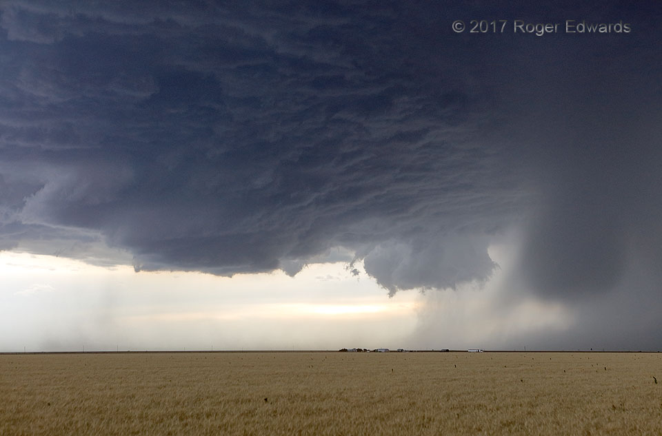
35.3175, -101.6185Wall Clouds and Microburst
A hard-right-moving supercell fired off the dryline in the Texas Panhandle and churned southward (right to left) toward and across eastern Amarillo. Before it got there, several high-based wall clouds appeared, related to mesocyclone cycles. Here, a newer, tiered wall cloud appears on the left (south) side, ahead of an older, ragged one with a deep occlusion at right rear. At far right, that “sagging water balloon” look is for a good reason: a microburst plunging down. Like that water balloon, a microburst is a very dense fluid compared to surroundings, except there’s no rubber skin to stop it. Only the ground will. Upon slamming into the surface, the current of heavy rain and cold air (probably including hail in this case) has nowhere to go but outward, with a horizontal, expanding-donut-shaped logrolling action that we weather scientists call a “toroid”. So it does, producing a ring of intense, usually severe and damaging wind that weakens with distance from the source, akin to a blast wave. The damage from microbursts can resemble that of an airburst bomb, with outward-divergent “starburst” patterns.
6 NE Amarillo TX (8 Jun 17) Looking WNW
35.3175, -101.6185