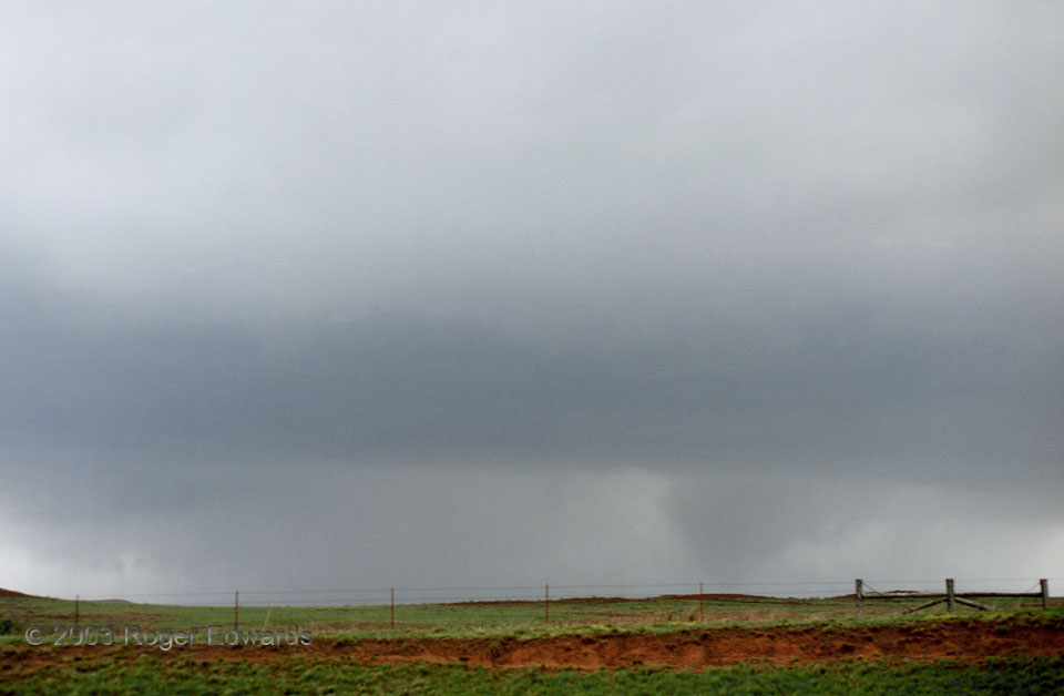
 The tornado to right of center, which we barely saw with our eyeballs, was buried in heavy precipitation wrapping around the mesocyclone, and was located northeast of the bulk of rain and hail with this supercell. Such an orientation of a storm’s “business end” is actually rather common in HP (heavy precip) supercells, which may assume a figure-9 pattern to the most dense precipitation. When HP storms contain a tornado, it often will be tucked away dangerously within the closed loop of the “9.” S everal nearby lightning strikes, and intermittent large hail, kept me in the car and unable to use a tripod. Still, although the conditions were quite dark and poor for photography, I was able to compensate somewhat by bracketing several deliberate overexposures with the slide film. Somehow my passengers sat still, and I kept a steady hand just long enough to expose this shot for about 1/15 of a second. Good fortune helped too, in having one hand-held, low light image fail to blur from the shaking of the car amidst gusty inflow winds. Several of the tornadoes I saw in 2003 were low-contrast, rain-wrapped vortices such as this, which may go unnoticed to the untrained eye or to the inexperienced spotter focused intently on the wrong part of the storm off to the left.
4 N Cheyenne OK (15 Apr 3) Looking WSW
35.6681, -99.6732
RADAR
The tornado to right of center, which we barely saw with our eyeballs, was buried in heavy precipitation wrapping around the mesocyclone, and was located northeast of the bulk of rain and hail with this supercell. Such an orientation of a storm’s “business end” is actually rather common in HP (heavy precip) supercells, which may assume a figure-9 pattern to the most dense precipitation. When HP storms contain a tornado, it often will be tucked away dangerously within the closed loop of the “9.” S everal nearby lightning strikes, and intermittent large hail, kept me in the car and unable to use a tripod. Still, although the conditions were quite dark and poor for photography, I was able to compensate somewhat by bracketing several deliberate overexposures with the slide film. Somehow my passengers sat still, and I kept a steady hand just long enough to expose this shot for about 1/15 of a second. Good fortune helped too, in having one hand-held, low light image fail to blur from the shaking of the car amidst gusty inflow winds. Several of the tornadoes I saw in 2003 were low-contrast, rain-wrapped vortices such as this, which may go unnoticed to the untrained eye or to the inexperienced spotter focused intently on the wrong part of the storm off to the left.
4 N Cheyenne OK (15 Apr 3) Looking WSW
35.6681, -99.6732
RADARVortex Within
 The tornado to right of center, which we barely saw with our eyeballs, was buried in heavy precipitation wrapping around the mesocyclone, and was located northeast of the bulk of rain and hail with this supercell. Such an orientation of a storm’s “business end” is actually rather common in HP (heavy precip) supercells, which may assume a figure-9 pattern to the most dense precipitation. When HP storms contain a tornado, it often will be tucked away dangerously within the closed loop of the “9.” S everal nearby lightning strikes, and intermittent large hail, kept me in the car and unable to use a tripod. Still, although the conditions were quite dark and poor for photography, I was able to compensate somewhat by bracketing several deliberate overexposures with the slide film. Somehow my passengers sat still, and I kept a steady hand just long enough to expose this shot for about 1/15 of a second. Good fortune helped too, in having one hand-held, low light image fail to blur from the shaking of the car amidst gusty inflow winds. Several of the tornadoes I saw in 2003 were low-contrast, rain-wrapped vortices such as this, which may go unnoticed to the untrained eye or to the inexperienced spotter focused intently on the wrong part of the storm off to the left.
4 N Cheyenne OK (15 Apr 3) Looking WSW
35.6681, -99.6732
RADAR