SkyPix

A digital photographic storybook of clouds, weather and water by Roger Edwards.

  • Home
  • Newest Posts
  • Galleries
    • Aerial
    • All Hail
    • Burnscapes
    • Daytime Lightning
    • Floods
    • Fog and Mist
    • Gallery of Outflow
    • Hurricane Andrew
    • Mini Cloud Atlas
    • Night Lightning
    • Mostly Okie Winters
    • Sunsets and Sunrises
    • The Majestic Supercell
    • Tornadoes
    • Unusual Weather Damage
    • Visual Effects
    • Wall Cloud Wall
    • Water Works
  • About
  • F.A.Q.
  • Contact

View into the Notch

2022-07-07 By Roger Edwards

View into the Notch

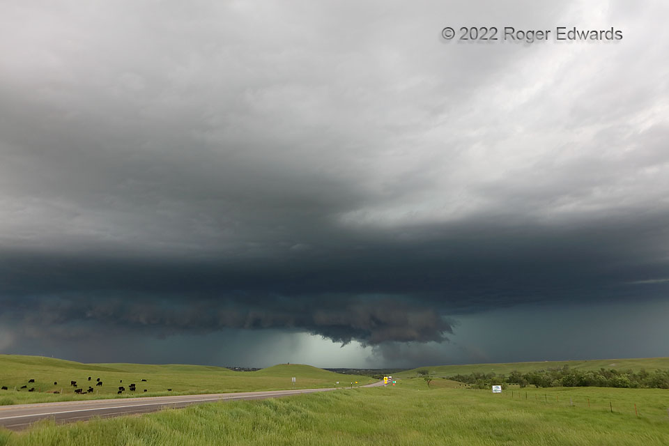
The messy supercell, that I first intercepted a couple hours before west of Alzada, MT, had raced east-southeastward to Belle Fourche, encountering richer moisture along the way, and was fixing to move into town with hurricane-force gusts and 4-inch-diameter hail.  As my late friend Jim Leonard said about another giant-hail-producing supercell he filmed in the mid-1980s, this storm was “serious business now”.  Even among Great Plains supercells, it was exceptionally severe and dangerous.  Here, only about a mile from where I stopped to shoot another speedy supercell the day before, we can see the wall cloud well.  It was rotating fairly strongly, drawing inflow both from unimpeded warm sector and (in back right) from the forward-flank core, but couldn’t quite produce a tornado.  That’s good for Belle Fourche, despite all the other destruction this storm wrought.  This also was well-sampled by TORUS project mobile radars and mesonets, one of which measured a 91-mph gust in the rear-flank downdraft.  Forward (right) and rear (left) flanks filled with intense, flooding rains and hail, leaving this large updraft base and mesocyclone to occupy the inner corner of the inflow a notch in between, shaped in two dimensions much like Pac-Man’s mouth.  With this storm chomping right in my direction, I only lingered for a few more shots before escaping again through St. Onge, and down Interstate 90, only to watch another supercell form atop horizontal rolls in the warm sector, then merge with this one.

5 NW St. Onge SD (12 Jun 22) Looking WNW
44.6035, -103.7798

Filed Under: The Majestic Supercell, Wall Cloud Wall Tagged With: Belle Fourche, clouds, convection, Great Plains, highways, Saint Onge, South Dakota, storms, supercells, thunderstorms, wall clouds, weather

Previous: Electrified Twilight Sky
Next: Quad-Flash Twilight

About

Welcome to SkyPix, an online photo book of clouds, weather and water by Roger Edwards. As in a printed coffee-table book, every image has its own page with a unique story. After all, meaningful photography is much more than just picture-taking; it is visually rendering a moment in place and time from a perspective like none other. As a scientist and an artist, I hope my deep passion for the power and splendor of our skies and waters shines through in these pages. If you are a cloud and weather aficionado, outdoor enthusiast, outdoor or nature photographer, art lover, or anyone who craves learning, enjoy...

More

Further images from this photographer may be found at:
Roger Edwards Image of the Week
Roger Edwards Digital Galleries
Storms Observed Chase BLOG

Copyright © 2025 ROGER EDWARDS SKYPIX.PHOTOGRAPHY ALL RIGHTS RESERVED. · Design by INSOJOURN Design and Images · WordPress · Log in