SkyPix

A digital photographic storybook of clouds, weather and water by Roger Edwards.

  • Home
  • Newest Posts
  • Galleries
    • Aerial
    • All Hail
    • Burnscapes
    • Daytime Lightning
    • Floods
    • Fog and Mist
    • Gallery of Outflow
    • Hurricane Andrew
    • Mini Cloud Atlas
    • Night Lightning
    • Mostly Okie Winters
    • Sunsets and Sunrises
    • The Majestic Supercell
    • Tornadoes
    • Unusual Weather Damage
    • Visual Effects
    • Wall Cloud Wall
    • Water Works
  • About
  • F.A.Q.
  • Contact

Upward Vertical Motion, Two Ways

2022-08-19 By Roger Edwards

Upward Vertical Motion, Two Ways

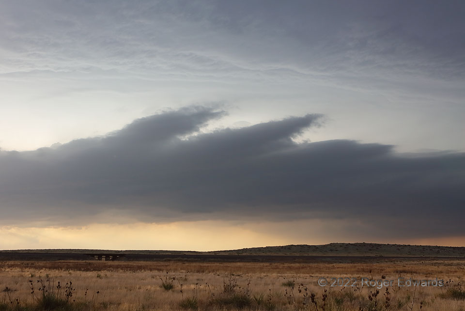
One may be forgiven for mistaking the lower cloud base for that of a thunderstorm, if not for the detachment of the feature from the second deck above, which really was a storm base (with unseen deep towers aloft).  This bizarre and transient formation developed beneath a swath of rapidly growing elevated convection that soon would become surface-based , as its updrafts accessed a diurnally heated and destabilized boundary layer from which its genesis inflow parcels had been segregated.  Horizontal manifestations can be seen of K-H waves that lifted enough air to create shallow, domed, still mostly laminar towers on top (visible at middle center and far right middle).  A cloud formation like this is mostly stratiform, partly convective, and defines readily classification.   It also was very short-lived.  As the boundary-layer door opened into the updraft, this entire miles-long feature vanished in both rain and inflow in under a minute.

11 N Boise City OK (7 Jun 22) Looking NW
36.8825, -102.5175


Filed Under: Mini Cloud Atlas Tagged With: Boise City, clouds, convection, Great Plains, Kelvin-Helmholtz waves, landscapes, Oklahoma, Oklahoma Panhandle, storms, stratus, thunderstorms, weather

Previous: Blasting Belle Fourche
Next: Cottonwood Shelf: South View

About

Welcome to SkyPix, an online photo book of clouds, weather and water by Roger Edwards. As in a printed coffee-table book, every image has its own page with a unique story. After all, meaningful photography is much more than just picture-taking; it is visually rendering a moment in place and time from a perspective like none other. As a scientist and an artist, I hope my deep passion for the power and splendor of our skies and waters shines through in these pages. If you are a cloud and weather aficionado, outdoor enthusiast, outdoor or nature photographer, art lover, or anyone who craves learning, enjoy...

More

Further images from this photographer may be found at:
Roger Edwards Image of the Week
Roger Edwards Digital Galleries
Storms Observed Chase BLOG

Copyright © 2025 ROGER EDWARDS SKYPIX.PHOTOGRAPHY ALL RIGHTS RESERVED. · Design by INSOJOURN Design and Images · WordPress · Log in