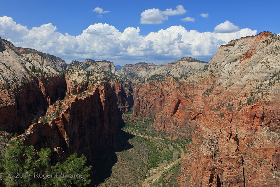
 To arrive here, one must hike a series of switchbacks adding up to 2.5 miles and 1500 vertical feet each way from the Virgin River, or a total of 5 miles and 3,000 vertical feet. Parts of the hike ain’t easy, traversing slick, tilted, sand-covered rock slopes bracketed by thousand-foot dropoffs within just a few feet distance on either side (or sometimes both sides at once). Needless to say, the view was worth both the hike and roughly 45 minutes’ rest, picnic lunch, and appreciation at the top, to refuel and reload for the journey back down. It’s so important to monitor weather conditions for this hike, because you do not want to get caught in a thunderstorm up here. That feeble-looking little stream has carved Zion Canyon through the hard and colorful Navajo Sandstone, a crossbedded unit compacted from thousands of feet of a huge early Jurassic desert’s dune sands. Upstream storms, such as those that were developing this day from the distant towering cumulus and congestus, send flash floods downriver that perform a great deal of the excavation work, grain by grain, boulder by boulder. Freeze-thaw cycles push rock loose on the cliffs too, as expanding ice in cracks and pores of the stone pry gaps open, wider and wider, until a slab breaks off and falls.
6 NNE Springdale UT (7 Aug 17) Looking N
37.2698, -112.9478
To arrive here, one must hike a series of switchbacks adding up to 2.5 miles and 1500 vertical feet each way from the Virgin River, or a total of 5 miles and 3,000 vertical feet. Parts of the hike ain’t easy, traversing slick, tilted, sand-covered rock slopes bracketed by thousand-foot dropoffs within just a few feet distance on either side (or sometimes both sides at once). Needless to say, the view was worth both the hike and roughly 45 minutes’ rest, picnic lunch, and appreciation at the top, to refuel and reload for the journey back down. It’s so important to monitor weather conditions for this hike, because you do not want to get caught in a thunderstorm up here. That feeble-looking little stream has carved Zion Canyon through the hard and colorful Navajo Sandstone, a crossbedded unit compacted from thousands of feet of a huge early Jurassic desert’s dune sands. Upstream storms, such as those that were developing this day from the distant towering cumulus and congestus, send flash floods downriver that perform a great deal of the excavation work, grain by grain, boulder by boulder. Freeze-thaw cycles push rock loose on the cliffs too, as expanding ice in cracks and pores of the stone pry gaps open, wider and wider, until a slab breaks off and falls.
6 NNE Springdale UT (7 Aug 17) Looking N
37.2698, -112.9478Upstream from Angel’s Landing
 To arrive here, one must hike a series of switchbacks adding up to 2.5 miles and 1500 vertical feet each way from the Virgin River, or a total of 5 miles and 3,000 vertical feet. Parts of the hike ain’t easy, traversing slick, tilted, sand-covered rock slopes bracketed by thousand-foot dropoffs within just a few feet distance on either side (or sometimes both sides at once). Needless to say, the view was worth both the hike and roughly 45 minutes’ rest, picnic lunch, and appreciation at the top, to refuel and reload for the journey back down. It’s so important to monitor weather conditions for this hike, because you do not want to get caught in a thunderstorm up here. That feeble-looking little stream has carved Zion Canyon through the hard and colorful Navajo Sandstone, a crossbedded unit compacted from thousands of feet of a huge early Jurassic desert’s dune sands. Upstream storms, such as those that were developing this day from the distant towering cumulus and congestus, send flash floods downriver that perform a great deal of the excavation work, grain by grain, boulder by boulder. Freeze-thaw cycles push rock loose on the cliffs too, as expanding ice in cracks and pores of the stone pry gaps open, wider and wider, until a slab breaks off and falls.
6 NNE Springdale UT (7 Aug 17) Looking N
37.2698, -112.9478