SkyPix

A digital photographic storybook of clouds, weather and water by Roger Edwards.

  • Home
  • Newest Posts
  • Galleries
    • Aerial
    • All Hail
    • Burnscapes
    • Daytime Lightning
    • Floods
    • Fog and Mist
    • Gallery of Outflow
    • Hurricane Andrew
    • Mini Cloud Atlas
    • Night Lightning
    • Mostly Okie Winters
    • Sunsets and Sunrises
    • The Majestic Supercell
    • Tornadoes
    • Unusual Weather Damage
    • Visual Effects
    • Wall Cloud Wall
    • Water Works
  • About
  • F.A.Q.
  • Contact

Updraft: Historic OKC Hailstorm

2016-07-26 By Roger Edwards

Updraft: Historic OKC Hailstorm

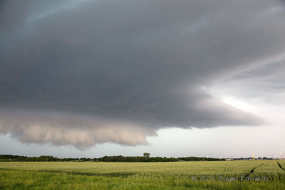
We thought it was too marginal of a chase day to mess with.  That was mistaken.  Several of us veteran chasers sat around the table at a lunch buffet, swapping stories of storms of yore and packing away piles of vittles, when a storm blew up fast on an old boundary NW of Oklahoma City.  Tapping the boundary’s vorticity reservoir and turning sharply rightward, it overcame many seeming weaknesses of the broader-scale environment and embarked on a 6-hour journey of mayhem and destruction through the OKC area and into southeast Oklahoma.  We all dispersed like roaches with the lights turned on, except to retrieve our gear and observe this storm.  After Elke and I zipped home to pick up our cameras, we caught the front end of the massive, messy supercell in eastern OKC as its core enveloped the city to our NW, instrument-measured winds to 60 mph, and hail up to 4-1/4 inches in diameter injuring 21 people and causing hundreds of millions of dollars in damage across a wide swath.  An extremely hyperbole-prone local TV weatherman came over the radio:  “We’re under attack at the studios!  Skylights are breaking, baseball hail falling right here!  We are under attack!  This storm is taking no prisoners.”  Fortunately we stayed ahead of the giant hail, finally finding a good vantage without buildings and nearby trees several miles farther east.  By then, the supercell formed a pronounced, rotating updraft area on its front flank, unusually illuminated from the east.  These features soon got undercut by outflow, and the storm continued its rampage southeastward into the deep woods.

2 SSW Dale OK (16 May 10) Looking NW
35.3654, -97.0544

Filed Under: The Majestic Supercell Tagged With: clouds, convection, Dale, landscapes, Oklahoma, storms, supercells, thunderstorms, wall clouds, weather

Previous: Layers over Lightning
Next: Sundown Grooming

About

Welcome to SkyPix, an online photo book of clouds, weather and water by Roger Edwards. As in a printed coffee-table book, every image has its own page with a unique story. After all, meaningful photography is much more than just picture-taking; it is visually rendering a moment in place and time from a perspective like none other. As a scientist and an artist, I hope my deep passion for the power and splendor of our skies and waters shines through in these pages. If you are a cloud and weather aficionado, outdoor enthusiast, outdoor or nature photographer, art lover, or anyone who craves learning, enjoy...

More

Further images from this photographer may be found at:
Roger Edwards Image of the Week
Roger Edwards Digital Galleries
Storms Observed Chase BLOG

Copyright © 2025 ROGER EDWARDS SKYPIX.PHOTOGRAPHY ALL RIGHTS RESERVED. · Design by INSOJOURN Design and Images · WordPress · Log in