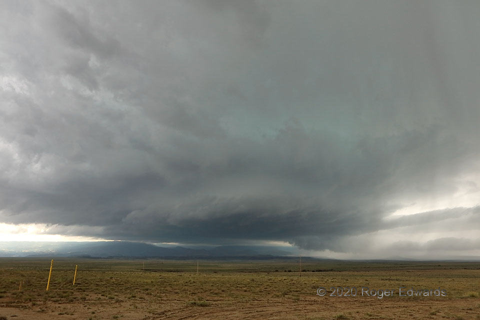
 This storm formed over the Sangre de Cristos west of Trinidad, and was a well-developed supercell by the time it passed over town. By the time of this photo, east of Trinidad, the supercell had enlarged and clearly strengthened, sporting a very large updraft base, multiple tail clouds, and intermittent wall clouds. Entering richer moisture, the storm would intensify further, lower its based to what storm chasers sometimes call a “ground-scraping” look, and very nearly produce a tornado. The turquoise hue in midlevels gives away a deep, dense load of precipitation in the midlevels of the storm, including large hail (which also was detected by radar). Orographically directed backing or channeling of inflow along the north side of those background mesas, which stand a couple thousand feet above the surrounding High Plains, may have helped this storm, in an otherwise marginal environment, maintain intense supercellular organization. Only some surface stations that aren’t there, perhaps part of a dream-world Colorado mesonet, could help us to know with more certainty.
13 ENE Trinidad CO (19 Jun 20) Looking SW
37.209, -104.2497
This storm formed over the Sangre de Cristos west of Trinidad, and was a well-developed supercell by the time it passed over town. By the time of this photo, east of Trinidad, the supercell had enlarged and clearly strengthened, sporting a very large updraft base, multiple tail clouds, and intermittent wall clouds. Entering richer moisture, the storm would intensify further, lower its based to what storm chasers sometimes call a “ground-scraping” look, and very nearly produce a tornado. The turquoise hue in midlevels gives away a deep, dense load of precipitation in the midlevels of the storm, including large hail (which also was detected by radar). Orographically directed backing or channeling of inflow along the north side of those background mesas, which stand a couple thousand feet above the surrounding High Plains, may have helped this storm, in an otherwise marginal environment, maintain intense supercellular organization. Only some surface stations that aren’t there, perhaps part of a dream-world Colorado mesonet, could help us to know with more certainty.
13 ENE Trinidad CO (19 Jun 20) Looking SW
37.209, -104.2497Turquoise from Trinidad
 This storm formed over the Sangre de Cristos west of Trinidad, and was a well-developed supercell by the time it passed over town. By the time of this photo, east of Trinidad, the supercell had enlarged and clearly strengthened, sporting a very large updraft base, multiple tail clouds, and intermittent wall clouds. Entering richer moisture, the storm would intensify further, lower its based to what storm chasers sometimes call a “ground-scraping” look, and very nearly produce a tornado. The turquoise hue in midlevels gives away a deep, dense load of precipitation in the midlevels of the storm, including large hail (which also was detected by radar). Orographically directed backing or channeling of inflow along the north side of those background mesas, which stand a couple thousand feet above the surrounding High Plains, may have helped this storm, in an otherwise marginal environment, maintain intense supercellular organization. Only some surface stations that aren’t there, perhaps part of a dream-world Colorado mesonet, could help us to know with more certainty.
13 ENE Trinidad CO (19 Jun 20) Looking SW
37.209, -104.2497