SkyPix

A digital photographic storybook of clouds, weather and water by Roger Edwards.

  • Home
  • Newest Posts
  • Galleries
    • Aerial
    • All Hail
    • Burnscapes
    • Daytime Lightning
    • Floods
    • Fog and Mist
    • Gallery of Outflow
    • Hurricane Andrew
    • Mini Cloud Atlas
    • Night Lightning
    • Mostly Okie Winters
    • Sunsets and Sunrises
    • The Majestic Supercell
    • Tornadoes
    • Unusual Weather Damage
    • Visual Effects
    • Wall Cloud Wall
    • Water Works
  • About
  • F.A.Q.
  • Contact

True ACSL

2022-10-18 By Roger Edwards

True ACSL

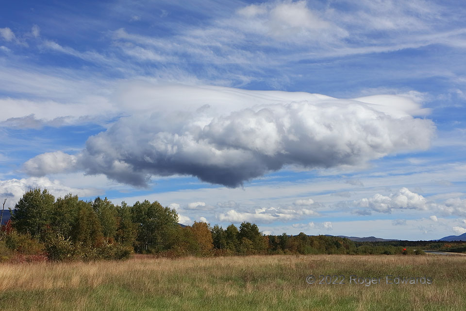
Traditional observing rule and cloud charts tag mountain-wave lenticulars as “altocumulus standing lenticularis” (ACSL)—even if the lenticular cloud has no convective, cumuliform component at all.  Literally speaking, the AC part, and especially C, is usually wrong.  Most lenticular clouds are entirely laminar, not convective, and thus should be altostratus standing lenticularis (ASSL), an abbreviation you’ll never see in observations nor observing manuals.  As you easily can see, however, this formation truly was convective and laminar!  It stayed anchored in place for over half an hour, within and beneath a standing wave in the White Mountains, continually sporting a lenticular top and convective bottom.  I’ve never seen anything quite like it, but it was easy to explain meteorologically.  This cloud was a fascinating case of rising motion in the upward part of the midlevel standing wave being enough to bring some boundary-layer air below it to a level of (very shallow) free convection. Midlevel lapse rates—steepened near the cold core of a cyclone aloft—overlapped a moist and diabatically heated boundary layer with weak capping.  The convection supplied moisture to the standing wave above, where temperatures were cold enough to make ice crystals for the lenticular formation, and never penetrated past it due to too much convective stability in the higher layer.  Because this was near a local airport (see runway at right), any small plane taking off or approaching through this cloud would have had a strongly turbulent, dangerous experience.  That’s why manually augmented weather observations often note lenticulars seen.

3 ESE Whitefield NH (27 Sep 22) Looking E
44.3682, -71.5559


Filed Under: Mini Cloud Atlas Tagged With: altocumulus, altocumulus lenticularis, Appalachian Mountains, cirrus, clouds, convection, Cumulus humilis, landscapes, lenticular, New England, New Hampshire, weather, White Mountains, Whitefield

Previous: Dusty Supercell Spotting
Next: Autumn Reflective

About

Welcome to SkyPix, an online photo book of clouds, weather and water by Roger Edwards. As in a printed coffee-table book, every image has its own page with a unique story. After all, meaningful photography is much more than just picture-taking; it is visually rendering a moment in place and time from a perspective like none other. As a scientist and an artist, I hope my deep passion for the power and splendor of our skies and waters shines through in these pages. If you are a cloud and weather aficionado, outdoor enthusiast, outdoor or nature photographer, art lover, or anyone who craves learning, enjoy...

More

Further images from this photographer may be found at:
Roger Edwards Image of the Week
Roger Edwards Digital Galleries
Storms Observed Chase BLOG

Copyright © 2025 ROGER EDWARDS SKYPIX.PHOTOGRAPHY ALL RIGHTS RESERVED. · Design by INSOJOURN Design and Images · WordPress · Log in