 If it weren’t weird enough that the former Plainview supercell assumed a triangular shape, it then grew these “wings”: dual tail clouds bracketing the still-triangular updraft with nearly perfect symmetry. Now it looked like some sort of enormous, imposing, alien spacecraft cruising in for a landing. The tail clouds represent enhanced areas of low-level convergence and lift, each forcing rain-cooled air from adjacent cores above their lifted condensation level—where the air cools enough to condense. What forced such lift so quickly and strongly? Partly it was the internal dynamics of this supercell; the low-pressure area responsible for the storm’s rotation boosts its lifting ability far beyond what buoyancy alone will support. Also, I suspect (without enough observational data to say for sure) that this storm’s very narrow inflow channel, a corridor of relatively undisturbed, warm, moist air to its northeast, was being constricted by growing storms to the south (left), temporarily increasing low-level convergence too. Despite having been heavy-precip (HP) in character for some time, the updraft base had expanded substantially if temporarily into that inflow channel, and the small wall cloud at lower left even was rotating.
7 WSW Flomot TX (15 Jun 19) Looking SW
34.2022, -101.1011
If it weren’t weird enough that the former Plainview supercell assumed a triangular shape, it then grew these “wings”: dual tail clouds bracketing the still-triangular updraft with nearly perfect symmetry. Now it looked like some sort of enormous, imposing, alien spacecraft cruising in for a landing. The tail clouds represent enhanced areas of low-level convergence and lift, each forcing rain-cooled air from adjacent cores above their lifted condensation level—where the air cools enough to condense. What forced such lift so quickly and strongly? Partly it was the internal dynamics of this supercell; the low-pressure area responsible for the storm’s rotation boosts its lifting ability far beyond what buoyancy alone will support. Also, I suspect (without enough observational data to say for sure) that this storm’s very narrow inflow channel, a corridor of relatively undisturbed, warm, moist air to its northeast, was being constricted by growing storms to the south (left), temporarily increasing low-level convergence too. Despite having been heavy-precip (HP) in character for some time, the updraft base had expanded substantially if temporarily into that inflow channel, and the small wall cloud at lower left even was rotating.
7 WSW Flomot TX (15 Jun 19) Looking SW
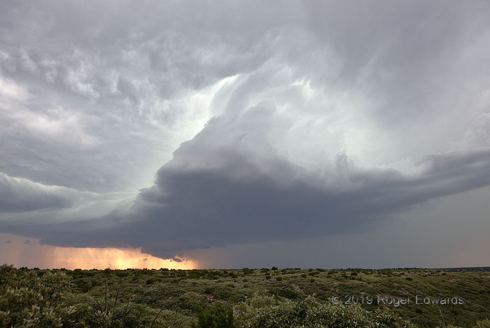
34.2022, -101.1011Triangular Supercell Grew Wings
If it weren’t weird enough that the former Plainview supercell assumed a triangular shape, it then grew these “wings”: dual tail clouds bracketing the still-triangular updraft with nearly perfect symmetry. Now it looked like some sort of enormous, imposing, alien spacecraft cruising in for a landing. The tail clouds represent enhanced areas of low-level convergence and lift, each forcing rain-cooled air from adjacent cores above their lifted condensation level—where the air cools enough to condense. What forced such lift so quickly and strongly? Partly it was the internal dynamics of this supercell; the low-pressure area responsible for the storm’s rotation boosts its lifting ability far beyond what buoyancy alone will support. Also, I suspect (without enough observational data to say for sure) that this storm’s very narrow inflow channel, a corridor of relatively undisturbed, warm, moist air to its northeast, was being constricted by growing storms to the south (left), temporarily increasing low-level convergence too. Despite having been heavy-precip (HP) in character for some time, the updraft base had expanded substantially if temporarily into that inflow channel, and the small wall cloud at lower left even was rotating.
7 WSW Flomot TX (15 Jun 19) Looking SW
34.2022, -101.1011