 The supercell already had offered a pleasant dose of high-based scenery two hours before, and a gustnado near a previous mesocyclonic occlusion in the intervening hour. Although the southeastward-moving storm remained high-based as it approached the Richland/Piedmont area, we surmised that it might have one brief shot at a tornado, when the outflow of a left (on this day, northeast) moving supercell to the south got ingested into the mesocyclone. This was because: 1) horizontal vorticity on a rear-flank gust front of an anticyclonic supercell is cyclonic in character, and 2) the part of the gust front destined to hit the mesocyclone was far enough from its parent downdraft that it might not be stable enough to kill the mesocyclone, at least not quickly. This meant, in short, that the mesocyclone had good reason to get very happy and spin tightly for a brief bit. We positioned ourselves accordingly, and so it was—except that the resulting tornado didn’t have a condensation funnel for several minutes. Instead, the cloud base above spun furiously with a bowl of rotating dust directly beneath. Funnel-free tornadoes actually are fairly common, at least at some stage in a tornado’s lifespan. This one waited to develop a condensation funnel for several more minutes, until I was driving and repositioning to evade huge hail, and I was unable to stop safely to shoot before the tornado ended.
4 NNW Richland OK (29 May 12) Looking NW
35.6383, -97.8234
RADAR
The supercell already had offered a pleasant dose of high-based scenery two hours before, and a gustnado near a previous mesocyclonic occlusion in the intervening hour. Although the southeastward-moving storm remained high-based as it approached the Richland/Piedmont area, we surmised that it might have one brief shot at a tornado, when the outflow of a left (on this day, northeast) moving supercell to the south got ingested into the mesocyclone. This was because: 1) horizontal vorticity on a rear-flank gust front of an anticyclonic supercell is cyclonic in character, and 2) the part of the gust front destined to hit the mesocyclone was far enough from its parent downdraft that it might not be stable enough to kill the mesocyclone, at least not quickly. This meant, in short, that the mesocyclone had good reason to get very happy and spin tightly for a brief bit. We positioned ourselves accordingly, and so it was—except that the resulting tornado didn’t have a condensation funnel for several minutes. Instead, the cloud base above spun furiously with a bowl of rotating dust directly beneath. Funnel-free tornadoes actually are fairly common, at least at some stage in a tornado’s lifespan. This one waited to develop a condensation funnel for several more minutes, until I was driving and repositioning to evade huge hail, and I was unable to stop safely to shoot before the tornado ended.
4 NNW Richland OK (29 May 12) Looking NW
35.6383, -97.8234
RADARTornado without Funnel
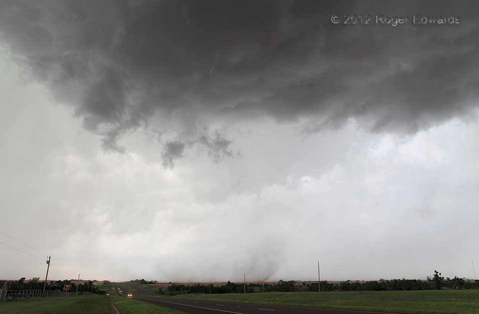
The supercell already had offered a pleasant dose of high-based scenery two hours before, and a gustnado near a previous mesocyclonic occlusion in the intervening hour. Although the southeastward-moving storm remained high-based as it approached the Richland/Piedmont area, we surmised that it might have one brief shot at a tornado, when the outflow of a left (on this day, northeast) moving supercell to the south got ingested into the mesocyclone. This was because: 1) horizontal vorticity on a rear-flank gust front of an anticyclonic supercell is cyclonic in character, and 2) the part of the gust front destined to hit the mesocyclone was far enough from its parent downdraft that it might not be stable enough to kill the mesocyclone, at least not quickly. This meant, in short, that the mesocyclone had good reason to get very happy and spin tightly for a brief bit. We positioned ourselves accordingly, and so it was—except that the resulting tornado didn’t have a condensation funnel for several minutes. Instead, the cloud base above spun furiously with a bowl of rotating dust directly beneath. Funnel-free tornadoes actually are fairly common, at least at some stage in a tornado’s lifespan. This one waited to develop a condensation funnel for several more minutes, until I was driving and repositioning to evade huge hail, and I was unable to stop safely to shoot before the tornado ended.
4 NNW Richland OK (29 May 12) Looking NW
35.6383, -97.8234
RADAR