SkyPix

A digital photographic storybook of clouds, weather and water by Roger Edwards.

  • Home
  • Newest Posts
  • Galleries
    • Aerial
    • All Hail
    • Burnscapes
    • Daytime Lightning
    • Floods
    • Fog and Mist
    • Gallery of Outflow
    • Hurricane Andrew
    • Mini Cloud Atlas
    • Night Lightning
    • Mostly Okie Winters
    • Sunsets and Sunrises
    • The Majestic Supercell
    • Tornadoes
    • Unusual Weather Damage
    • Visual Effects
    • Wall Cloud Wall
    • Water Works
  • About
  • F.A.Q.
  • Contact

Tornado Spotting the Old Mesocyclone

2021-05-11 By Roger Edwards

Tornado Spotting the Old Mesocyclone

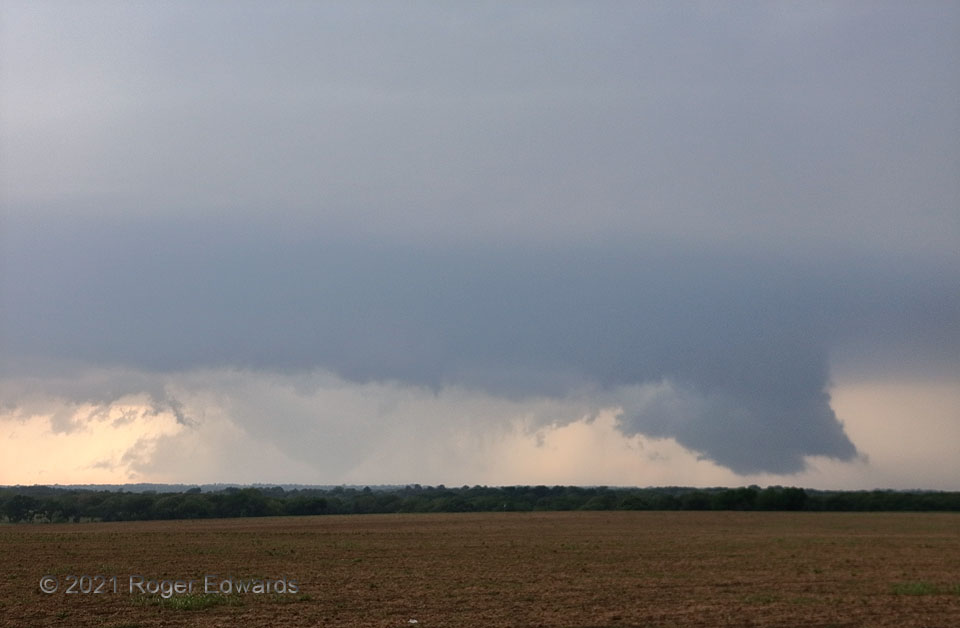
This view offers a classic storm-spotting lesson.  Paying close attention to radar and NWS warnings upshear, and being in a tornado watch, the diligent spotter knows a supercell is approaching from the west, has prepared for this, and immediately springs into duty.  Upon emerging from the low, wooded area of Hill Country to the north and west to occupy a good, high vantage, the spotter  sees the supercellular scene emerge.  One’s attention naturally focuses on the low-based wall cloud at right, which was weakly rotating, with rapidly rising scud on its tail facing the forward-flank core.  That’s often a sign of near-term tornado potential and absolutely should be watched closely.  Yet it’s so important not to fixate!  If so, one could miss the rain-wrapped, bowl- or fat-cone-shaped tornado ongoing in the core southwest (behind and left) of the wall cloud.  There are two mesocyclones underway here:  the newer one with the wall cloud, and the older, deeply occluded one with the more immediately dangerous actual tornado!  The visible part of this tornado would narrow at the top, increase in contrast, and contort into different shapes, destroying a wedding venue at Blum, TX, shortly before dissipating.  Once the tornado is spotted, it’s important to report calmly the behavior of both the tornado and the newer wall cloud to its northeast (your west-northwest), and not get fixated on either for too long—all while having a plan to leave this location and get to another to the south or southeast, in case the storm turns right and threatens safety here.  Excellent storm spotting can be hard!

1 NNW Osceola TX (3 May 21) Looking W
32.1509, -97.2412

RADAR

Filed Under: Tornadoes, Wall Cloud Wall Tagged With: Blum, clouds, convection, Covington, Hill Country, landscapes, Osceola, storms, supercells, Texas, thunderstorms, tornado, wall clouds, weather

Previous: Big Bolts by Brookville
Next: Spiked Glacier

About

Welcome to SkyPix, an online photo book of clouds, weather and water by Roger Edwards. As in a printed coffee-table book, every image has its own page with a unique story. After all, meaningful photography is much more than just picture-taking; it is visually rendering a moment in place and time from a perspective like none other. As a scientist and an artist, I hope my deep passion for the power and splendor of our skies and waters shines through in these pages. If you are a cloud and weather aficionado, outdoor enthusiast, outdoor or nature photographer, art lover, or anyone who craves learning, enjoy...

More

Further images from this photographer may be found at:
Roger Edwards Image of the Week
Roger Edwards Digital Galleries
Storms Observed Chase BLOG

Copyright © 2025 ROGER EDWARDS SKYPIX.PHOTOGRAPHY ALL RIGHTS RESERVED. · Design by INSOJOURN Design and Images · WordPress · Log in