 This tornado’s debris cloud (lower left) was obviously well-displaced from its cloud-base vortex. So what caused such a severe tilt, how would this affect warning, and where would the tornado be recorded? Here, outflow from the high-based storm’s translucent core, near right edge, kept the bottom of the vortex tube near the same spot. Meanwhile the parent storm moved off to the northeast, stretching it for six minutes (this was the fifth) until the tornado vanished. Velocity signatures from fixed-site radars a few counties away would scan the parent mesocyclone somewhere higher in the cloud, misrepresenting the location of tornado danger by a few miles, because of the strong tilt of the vortex with height. This is one reason why storm spotters are still so important—and why warning forecasters fan out a margin for error on either side of the detected mesocyclone. The tornado’s location of record should be that of the debris cloud, because that’s where the damage occurs. A tornado is defined in time and space by its ground contact. Indeed, the phrase, “tornado on the ground”, is stupid and redundant. A tornado must be on the ground, or it’s not a tornado. Save words, save space, save time, be concise, and just say, “tornado”. [As an aside, this was a “day before the day” event, with “the day” being the outbreak that included the violent, long-tracked El Reno/Piedmont tornado.]
3 S Okeene OK (23 May 11) Looking NW
36.0726, -98.3177
RADAR
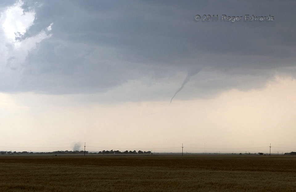
This tornado’s debris cloud (lower left) was obviously well-displaced from its cloud-base vortex. So what caused such a severe tilt, how would this affect warning, and where would the tornado be recorded? Here, outflow from the high-based storm’s translucent core, near right edge, kept the bottom of the vortex tube near the same spot. Meanwhile the parent storm moved off to the northeast, stretching it for six minutes (this was the fifth) until the tornado vanished. Velocity signatures from fixed-site radars a few counties away would scan the parent mesocyclone somewhere higher in the cloud, misrepresenting the location of tornado danger by a few miles, because of the strong tilt of the vortex with height. This is one reason why storm spotters are still so important—and why warning forecasters fan out a margin for error on either side of the detected mesocyclone. The tornado’s location of record should be that of the debris cloud, because that’s where the damage occurs. A tornado is defined in time and space by its ground contact. Indeed, the phrase, “tornado on the ground”, is stupid and redundant. A tornado must be on the ground, or it’s not a tornado. Save words, save space, save time, be concise, and just say, “tornado”. [As an aside, this was a “day before the day” event, with “the day” being the outbreak that included the violent, long-tracked El Reno/Piedmont tornado.]
3 S Okeene OK (23 May 11) Looking NW
36.0726, -98.3177
RADARTornadic Tilt
This tornado’s debris cloud (lower left) was obviously well-displaced from its cloud-base vortex. So what caused such a severe tilt, how would this affect warning, and where would the tornado be recorded? Here, outflow from the high-based storm’s translucent core, near right edge, kept the bottom of the vortex tube near the same spot. Meanwhile the parent storm moved off to the northeast, stretching it for six minutes (this was the fifth) until the tornado vanished. Velocity signatures from fixed-site radars a few counties away would scan the parent mesocyclone somewhere higher in the cloud, misrepresenting the location of tornado danger by a few miles, because of the strong tilt of the vortex with height. This is one reason why storm spotters are still so important—and why warning forecasters fan out a margin for error on either side of the detected mesocyclone. The tornado’s location of record should be that of the debris cloud, because that’s where the damage occurs. A tornado is defined in time and space by its ground contact. Indeed, the phrase, “tornado on the ground”, is stupid and redundant. A tornado must be on the ground, or it’s not a tornado. Save words, save space, save time, be concise, and just say, “tornado”. [As an aside, this was a “day before the day” event, with “the day” being the outbreak that included the violent, long-tracked El Reno/Piedmont tornado.]
3 S Okeene OK (23 May 11) Looking NW
36.0726, -98.3177
RADAR