SkyPix

A digital photographic storybook of clouds, weather and water by Roger Edwards.

  • Home
  • Newest Posts
  • Galleries
    • Aerial
    • All Hail
    • Burnscapes
    • Daytime Lightning
    • Floods
    • Fog and Mist
    • Gallery of Outflow
    • Hurricane Andrew
    • Mini Cloud Atlas
    • Night Lightning
    • Mostly Okie Winters
    • Sunsets and Sunrises
    • The Majestic Supercell
    • Tornadoes
    • Unusual Weather Damage
    • Visual Effects
    • Wall Cloud Wall
    • Water Works
  • About
  • F.A.Q.
  • Contact

Tornadic Bizarre Bazaar

2015-12-17 By Roger Edwards

Tornadic Bizarre Bazaar

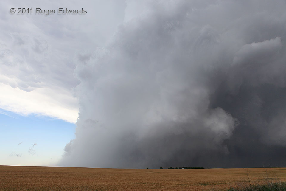
Truly one of the strangest supercell presentations I’ve ever witnessed—this storm formed in mid-morning near the center of an occluding low-level cyclone and stayed anchored near the low for several hours through the noon hour into mid-afternoon, trekking across much of northwestern Kansas into southern Nebraska, nearly 100 miles behind the dryline.  It survived by ingesting a narrow tongue of moist inflow to its north and northeast, along a bent-back occluded front.  This wide-angle view looks toward the southwest at the northward-moving supercell.  Do you see the huge tornado?  Look behind that row of trees in the distance.  That rain-wrapped wedge, often totally hidden from view, was one of several substantial tornadoes in a sequence within the main mesocyclone, which you can see as a tilted, surprisingly narrow convective chimney sloping away and to the right, well into the storm’s upper reaches.   The updraft tower isn’t much wider than the visible tornado funnel below cloud base!  In fact, since the tower was rotating visually at very rapid speeds, one plausibly can argue that we are seeing the tornado in middle and upper levels too—or at least, the tornado cyclone.   Rarely can one get such a stripped-down, skeletal view of a very wet supercell producing a big tornado.  To magnify the weirdness, we saw several small, dusty, mostly brief tornadoes away from the mesocyclone during the lifespan of the big one.   The secondary tornadoes quickly formed and died beneath transient, front-flank, cloud-base circulations to the right of the photo.   Notice also the storm’s lack of convection in its rear (left) side, and the sharp clearing behind that intense, divergent core of rear-flank precip.

3 S Long Island KS (20 Jun 11) Looking SW
39.901, -99.5354

RADAR

Filed Under: The Majestic Supercell, Tornadoes Tagged With: clouds, convection, Great Plains, Kansas, landscapes, Long Island, storms, supercells, thunderstorms, tornado, weather

Previous: Beyond Buttes
Next: Back to Future Sundown

About

Welcome to SkyPix, an online photo book of clouds, weather and water by Roger Edwards. As in a printed coffee-table book, every image has its own page with a unique story. After all, meaningful photography is much more than just picture-taking; it is visually rendering a moment in place and time from a perspective like none other. As a scientist and an artist, I hope my deep passion for the power and splendor of our skies and waters shines through in these pages. If you are a cloud and weather aficionado, outdoor enthusiast, outdoor or nature photographer, art lover, or anyone who craves learning, enjoy...

More

Further images from this photographer may be found at:
Roger Edwards Image of the Week
Roger Edwards Digital Galleries
Storms Observed Chase BLOG

Copyright © 2025 ROGER EDWARDS SKYPIX.PHOTOGRAPHY ALL RIGHTS RESERVED. · Design by INSOJOURN Design and Images · WordPress · Log in