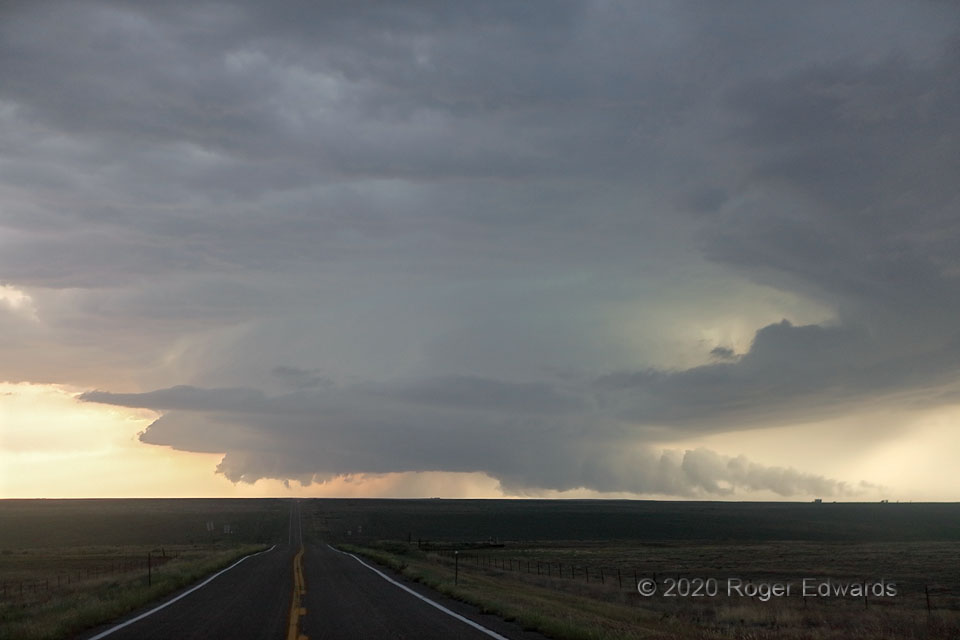
 “Tail-end Charlie” is a decades-old storm-chaser nickname for a supercell that forms on the equatorward fringe of a band of thunderstorms. This is that. Born and brewed on the southwest end of an afternoon-long convective plume, the big supercell got this way by catching a region of unimpeded inflow, backed boundary-layer winds, related enlargement of low-level hodographs, stronger shear, and lowered LCL (lifted condensation level) from the onset of surface cooling. This was about as close as it ever would come to producing a tornado, as rain-cooled air rushed in from the forward-flank core at lower right, to a broad and slowly rotating wall cloud. The storm peeled off its original convective area, right-moving south-southeast through deepening twilight to become the “Ordway” supercell at night.
9 E Punkin Center CO (4 Aug 20) Looking W
38.8506, -103.5314
“Tail-end Charlie” is a decades-old storm-chaser nickname for a supercell that forms on the equatorward fringe of a band of thunderstorms. This is that. Born and brewed on the southwest end of an afternoon-long convective plume, the big supercell got this way by catching a region of unimpeded inflow, backed boundary-layer winds, related enlargement of low-level hodographs, stronger shear, and lowered LCL (lifted condensation level) from the onset of surface cooling. This was about as close as it ever would come to producing a tornado, as rain-cooled air rushed in from the forward-flank core at lower right, to a broad and slowly rotating wall cloud. The storm peeled off its original convective area, right-moving south-southeast through deepening twilight to become the “Ordway” supercell at night.
9 E Punkin Center CO (4 Aug 20) Looking W
38.8506, -103.5314Tail-End Charlie
 “Tail-end Charlie” is a decades-old storm-chaser nickname for a supercell that forms on the equatorward fringe of a band of thunderstorms. This is that. Born and brewed on the southwest end of an afternoon-long convective plume, the big supercell got this way by catching a region of unimpeded inflow, backed boundary-layer winds, related enlargement of low-level hodographs, stronger shear, and lowered LCL (lifted condensation level) from the onset of surface cooling. This was about as close as it ever would come to producing a tornado, as rain-cooled air rushed in from the forward-flank core at lower right, to a broad and slowly rotating wall cloud. The storm peeled off its original convective area, right-moving south-southeast through deepening twilight to become the “Ordway” supercell at night.
9 E Punkin Center CO (4 Aug 20) Looking W
38.8506, -103.5314