SkyPix

A digital photographic storybook of clouds, weather and water by Roger Edwards.

  • Home
  • Newest Posts
  • Galleries
    • Aerial
    • All Hail
    • Burnscapes
    • Daytime Lightning
    • Floods
    • Fog and Mist
    • Gallery of Outflow
    • Hurricane Andrew
    • Mini Cloud Atlas
    • Night Lightning
    • Mostly Okie Winters
    • Sunsets and Sunrises
    • The Majestic Supercell
    • Tornadoes
    • Unusual Weather Damage
    • Visual Effects
    • Wall Cloud Wall
    • Water Works
  • About
  • F.A.Q.
  • Contact

Supercell Outflow Dominance

2023-11-06 By Roger Edwards

Outflow-Dominant Supercell

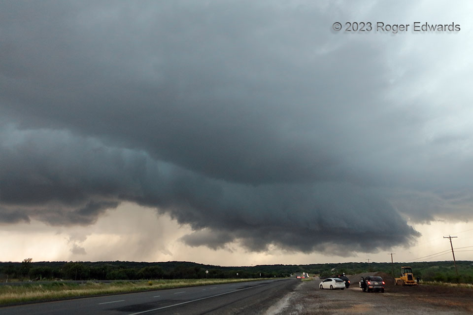
“Outflow-dominant” isn’t a popular term anymore with respect to supercells, but I don’t care.  I’m using it.  This was one.  That is why.  A supercell can be outflow-dominant and still maintain an existence, albeit a tenuous one, as most such storms ultimately lose a direct vertical pipeline of surface-based inflow air and either shrivel, merge with nearby storms and expand upscale into a wind machine, or become elevated.  What looks like an extensive shelf cloud mostly is, for the rear-flank gust front.  The mesocyclonic edge, north (right) of the highway, was a brief wall cloud with weak to moderate cloud-base rotation, still rotating but also being undercut by cold air the inner part of the rear-flank downdraft known as the occlusion downdraft.  Scud on the right side of the feature had raced up the cloud ramp from the vertical pressure-gradient forces of the low-level mesocyclone alone, but now was assisted by forced lift over the cold pool.  What is left of the wall cloud linked with the shelf for a continuous cloud feature, even as the north side (close to the vault) was behaving as a hybrid of the two still.  This storm would move over Brownwood, producing severe wind, hail and heavy rain,  with the gust front slightly retreating in a storm-relative sense, the still somewhat outflow-undercut mesocyclone nearly producing a weak tornado, before gusting out altogether.  A separate, third supercell of the day (for me) would form along the far part of the trailing gust front of this one at sunset, while I was searching for open fast food in a town beset by wailing storm sirens, but that storm got undercut quickly itself.

2 W Brownwood TX (6 May 23) Looking W
31.7212, -99.0202


Filed Under: Gallery of Outflow, The Majestic Supercell Tagged With: Brownwood, clouds, convection, Great Plains, highways, Hill Country, landscapes, scud, shelf cloud, storms, supercells, Texas, thunderstorms, wall clouds, weather

Previous: Almost
Next: Sparkin’ Behind the Farmhouse

About

Welcome to SkyPix, an online photo book of clouds, weather and water by Roger Edwards. As in a printed coffee-table book, every image has its own page with a unique story. After all, meaningful photography is much more than just picture-taking; it is visually rendering a moment in place and time from a perspective like none other. As a scientist and an artist, I hope my deep passion for the power and splendor of our skies and waters shines through in these pages. If you are a cloud and weather aficionado, outdoor enthusiast, outdoor or nature photographer, art lover, or anyone who craves learning, enjoy...

More

Further images from this photographer may be found at:
Roger Edwards Image of the Week
Roger Edwards Digital Galleries
Storms Observed Chase BLOG

Copyright © 2025 ROGER EDWARDS SKYPIX.PHOTOGRAPHY ALL RIGHTS RESERVED. · Design by INSOJOURN Design and Images · WordPress · Log in