SkyPix

A digital photographic storybook of clouds, weather and water by Roger Edwards.

  • Home
  • Newest Posts
  • Galleries
    • Aerial
    • All Hail
    • Burnscapes
    • Daytime Lightning
    • Floods
    • Fog and Mist
    • Gallery of Outflow
    • Hurricane Andrew
    • Mini Cloud Atlas
    • Night Lightning
    • Mostly Okie Winters
    • Sunsets and Sunrises
    • The Majestic Supercell
    • Tornadoes
    • Unusual Weather Damage
    • Visual Effects
    • Wall Cloud Wall
    • Water Works
  • About
  • F.A.Q.
  • Contact

Stout Tornado in the Oil Fields

2024-08-19 By Roger Edwards

Stout Tornado in the Oil Fields

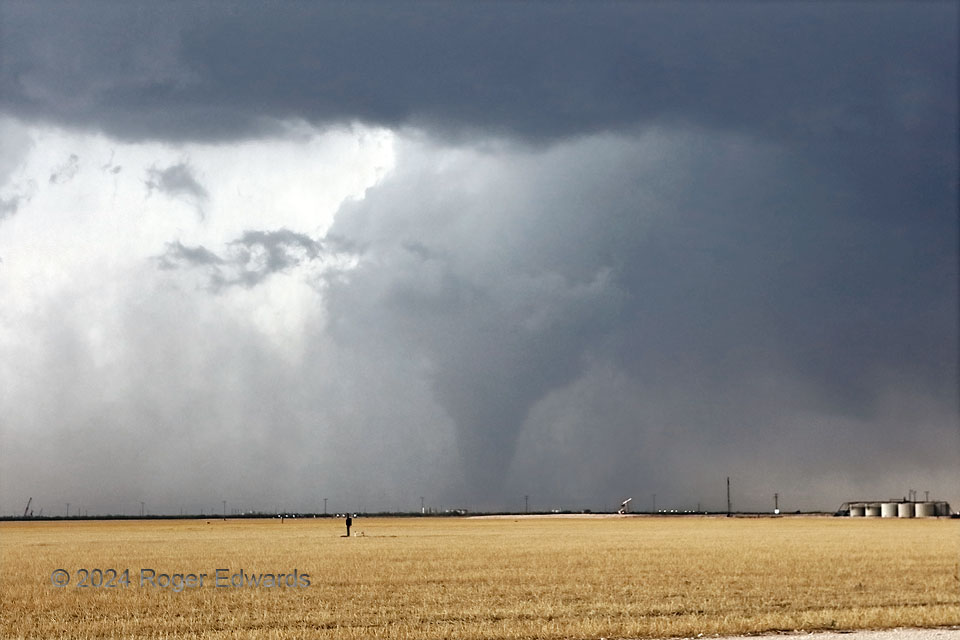
Here, the “Midland” tornado reached its best-organized stage, as a thick, tapered stovepipe, meandering slowly and erratically through the Permian Basin drilling region south of town.  An EF3 rating was earned based on some damage in the oil fields, at about this time.  Tornadoes that wreck actively used oil-field equipment or storage facilities can create spills and a hazardous materials (HAZMAT) situation, on top of the already-present human-safety emergency directly arising from the tornado itself.  I dread the inevitable day that a strong or especially violent one goes through the giant refining, transfer and pipeline facilities at Cushing, or across a major pipeline in heavy use anywhere.  As we watched this tornado from a safe distance, a lineup of oil-field service vehicles and workers inside, dismissed due to the tornado warnings, accumulated near our vehicle, which was pulled off the side of a side road.  Those who spoke English occasionally asked us questions about what was happening and where it was going.  Of course, we were glad to answer, alleviate fears, yet reinforce due respect for these powerful vortices.  Another strong tornado that I witnessed nine years earlier and about 300 miles to the north injured some oil workers.  Four years before that, a high-end violent tornado that I observed between El Reno and Piedmont earned an EF5 rating, based on engineering analysis of extreme and unprecedented damage it did to heavy, strongly anchored, metal oil rigging.

8 WSW Midkiff TX (30 May 24) Looking WNW
31.6089, -101.9775

RADAR

Filed Under: Tornadoes Tagged With: clouds, convection, Great Plains, landscapes, Midkiff, Midland, storms, supercells, Texas, thunderstorms, tornado, weather

Previous: Sun through Storm: Badlands
Next: Internal Illumination

About

Welcome to SkyPix, an online photo book of clouds, weather and water by Roger Edwards. As in a printed coffee-table book, every image has its own page with a unique story. After all, meaningful photography is much more than just picture-taking; it is visually rendering a moment in place and time from a perspective like none other. As a scientist and an artist, I hope my deep passion for the power and splendor of our skies and waters shines through in these pages. If you are a cloud and weather aficionado, outdoor enthusiast, outdoor or nature photographer, art lover, or anyone who craves learning, enjoy...

More

Further images from this photographer may be found at:
Roger Edwards Image of the Week
Roger Edwards Digital Galleries
Storms Observed Chase BLOG

Copyright © 2025 ROGER EDWARDS SKYPIX.PHOTOGRAPHY ALL RIGHTS RESERVED. · Design by INSOJOURN Design and Images · WordPress · Log in