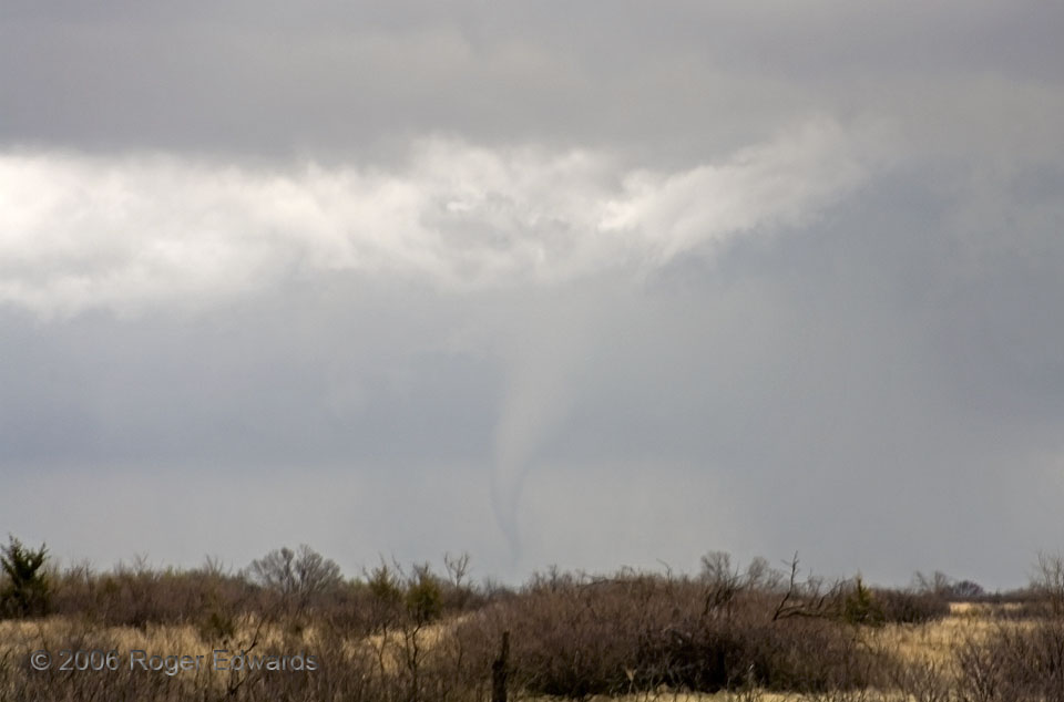
 This example, while not high contrast, is a fine spotting illustration of how a partly rain-wrapped tornado may look from the back (departing) side of a mesocyclone. During much of the mature supercell stage, we had been in good viewing position for the fast-moving supercell. Then it “barfed all over itself,” heaving a well defined gust front and a large, cold pool of outflow that appeared to obliterate the updraft region. Nothing seemed to remain but a large, turbulent shelf cloud’s underbelly, followed by an expanding area of rain. All coherent storm structure was lost. We let what we thought was the carcass of the storm get to our NE, following just behind (stern chasing) mainly out of convenience since it was en route to a road leading homeward from this part of southeastern Kansas. As we parked at the intersection, a clear slot appeared between us and some rain to our ENE, then a funnel appeared in the rain and gradually developed lower to the ground as the tornado formed. This was a shocker, to say the least. Somewhere, enough of an updraft was left—or developed anew along the weakening gust front—to get ahead of the outflow, ingest surface air, and rotate in tandem with some downdraft air to become tornadic.
1 SSE Buffalo KS (30 Mar 6) Looking NE
37.693, -95.6864
RADAR
This example, while not high contrast, is a fine spotting illustration of how a partly rain-wrapped tornado may look from the back (departing) side of a mesocyclone. During much of the mature supercell stage, we had been in good viewing position for the fast-moving supercell. Then it “barfed all over itself,” heaving a well defined gust front and a large, cold pool of outflow that appeared to obliterate the updraft region. Nothing seemed to remain but a large, turbulent shelf cloud’s underbelly, followed by an expanding area of rain. All coherent storm structure was lost. We let what we thought was the carcass of the storm get to our NE, following just behind (stern chasing) mainly out of convenience since it was en route to a road leading homeward from this part of southeastern Kansas. As we parked at the intersection, a clear slot appeared between us and some rain to our ENE, then a funnel appeared in the rain and gradually developed lower to the ground as the tornado formed. This was a shocker, to say the least. Somewhere, enough of an updraft was left—or developed anew along the weakening gust front—to get ahead of the outflow, ingest surface air, and rotate in tandem with some downdraft air to become tornadic.
1 SSE Buffalo KS (30 Mar 6) Looking NE
37.693, -95.6864
RADARStern-Chase Surprise
 This example, while not high contrast, is a fine spotting illustration of how a partly rain-wrapped tornado may look from the back (departing) side of a mesocyclone. During much of the mature supercell stage, we had been in good viewing position for the fast-moving supercell. Then it “barfed all over itself,” heaving a well defined gust front and a large, cold pool of outflow that appeared to obliterate the updraft region. Nothing seemed to remain but a large, turbulent shelf cloud’s underbelly, followed by an expanding area of rain. All coherent storm structure was lost. We let what we thought was the carcass of the storm get to our NE, following just behind (stern chasing) mainly out of convenience since it was en route to a road leading homeward from this part of southeastern Kansas. As we parked at the intersection, a clear slot appeared between us and some rain to our ENE, then a funnel appeared in the rain and gradually developed lower to the ground as the tornado formed. This was a shocker, to say the least. Somewhere, enough of an updraft was left—or developed anew along the weakening gust front—to get ahead of the outflow, ingest surface air, and rotate in tandem with some downdraft air to become tornadic.
1 SSE Buffalo KS (30 Mar 6) Looking NE
37.693, -95.6864
RADAR