SkyPix

A digital photographic storybook of clouds, weather and water by Roger Edwards.

  • Home
  • Newest Posts
  • Galleries
    • Aerial
    • All Hail
    • Burnscapes
    • Daytime Lightning
    • Floods
    • Fog and Mist
    • Gallery of Outflow
    • Hurricane Andrew
    • Mini Cloud Atlas
    • Night Lightning
    • Mostly Okie Winters
    • Sunsets and Sunrises
    • The Majestic Supercell
    • Tornadoes
    • Unusual Weather Damage
    • Visual Effects
    • Wall Cloud Wall
    • Water Works
  • About
  • F.A.Q.
  • Contact

Stacked-Plate Supercell over OU Campus

2024-10-04 By Roger Edwards

Stacked-Plate Supercell over OU Campus

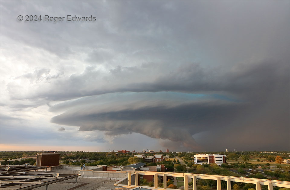
While at work on a supernumerary (for me, research) shift, and right after a seminar on (guess what) supercells, one developed northwest of Oklahoma City, then turned hard right (southeast) and dumped copious amounts of severe and often damaging hail.  Knowing the hodograph character and ambient flow, I figured this would be the easiest of chases; the storm would be a well-matured, photogenic, swirling ice machine by the time it got to Norman around sunset.  Since I’m all for amazing vantages of sunset supercells, I decided to chase it by riding an elevator to the roof when it got close enough.  In fact, I told the folks on forecast shift, “I’m not going anywhere, but upstairs.  No driving, no traffic, no gas burned.  Ringside seat, right here!”  The storm rolled into good camera range soon before sunset, just north of town as seen over the OU campus, as the warm “golden hour” rays were just starting to work under the cloud base and tickle the tip of the wall cloud.  Since it wasn’t producing lightning nearby, I stayed up there from here on past sunset, for views of a lifetime from atop my workplace, just a few months before retiring.  The turquoise light emanating from between the storm’s stacked-plate skirt and “ring of Saturn” feature above was a clue that it still had plenty of hail; indeed, several reports of severe hail followed the core across east Norman, between campus and Lake Thunderbird.

Norman OK (24 Sep 24) Looking N
35.1818, -97.4398

Filed Under: The Majestic Supercell Tagged With: cityscapes, clouds, convection, landscapes, National Weather Center, Norman, Oklahoma, storms, supercells, thunderstorms, University of Oklahoma, wall clouds, weather

Previous: Dallas Stratus
Next: Ring of Fire

About

Welcome to SkyPix, an online photo book of clouds, weather and water by Roger Edwards. As in a printed coffee-table book, every image has its own page with a unique story. After all, meaningful photography is much more than just picture-taking; it is visually rendering a moment in place and time from a perspective like none other. As a scientist and an artist, I hope my deep passion for the power and splendor of our skies and waters shines through in these pages. If you are a cloud and weather aficionado, outdoor enthusiast, outdoor or nature photographer, art lover, or anyone who craves learning, enjoy...

More

Further images from this photographer may be found at:
Roger Edwards Image of the Week
Roger Edwards Digital Galleries
Storms Observed Chase BLOG

Copyright © 2025 ROGER EDWARDS SKYPIX.PHOTOGRAPHY ALL RIGHTS RESERVED. · Design by INSOJOURN Design and Images · WordPress · Log in