SkyPix

A digital photographic storybook of clouds, weather and water by Roger Edwards.

  • Home
  • Newest Posts
  • Galleries
    • Aerial
    • All Hail
    • Burnscapes
    • Daytime Lightning
    • Floods
    • Fog and Mist
    • Gallery of Outflow
    • Hurricane Andrew
    • Mini Cloud Atlas
    • Night Lightning
    • Mostly Okie Winters
    • Sunsets and Sunrises
    • The Majestic Supercell
    • Tornadoes
    • Unusual Weather Damage
    • Visual Effects
    • Wall Cloud Wall
    • Water Works
  • About
  • F.A.Q.
  • Contact

Splitter with Overshoot

2015-03-11 By Roger Edwards

Splitter with Overshoot

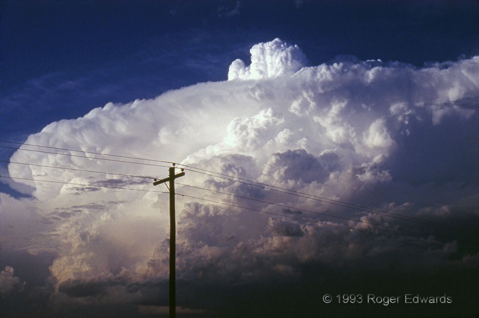
For all the beauty, wonder and immensity of the Great Plains, and all there is to see on every scale from hundred-mile skies to busy little ant trails, storms such as this are, first and foremost, what draw me across their long miles of roadways each spring.  This classic supercell exploded along a warm front to our NE while we were beneath a high-based, low-precip (LP) storm on the dryline about 30 miles to its SW.  The decision to pursue the warm front storm was ridiculously easy once it started looking like this!  This storm was full of convective treasures.  It thrust a series of deeply overshooting tops well into the lower stratosphere, this one punching upward as if a giant fist.  A close look at lower left reveals a classical updraft-splitting process being completed, with the small, left-most tower and base spinning anticyclonically, and the dominant updraft across the gap to its right rotating cyclonically.  “Knuckles” appears under the anvil rollover, above the anticyclonic updraft.  This storm never produced a tornado.  Still,  for the members of three storm intercept crews tag-teaming across the northwest Kansas plains, this was a sight to remember for a lifetime, and one old Ektachrome slide saved the memory for us all.

1 SE Norcatur KS (1 Jun 93) Looking NE
39.8275, -100.161

Filed Under: The Majestic Supercell Tagged With: clouds, convection. weather, Great Plains, Kansas, Norcatur, overshoot, storms, supercells, thunderstorms

Previous: Tilted Current
Next: Storm Season on the High Plains

About

Welcome to SkyPix, an online photo book of clouds, weather and water by Roger Edwards. As in a printed coffee-table book, every image has its own page with a unique story. After all, meaningful photography is much more than just picture-taking; it is visually rendering a moment in place and time from a perspective like none other. As a scientist and an artist, I hope my deep passion for the power and splendor of our skies and waters shines through in these pages. If you are a cloud and weather aficionado, outdoor enthusiast, outdoor or nature photographer, art lover, or anyone who craves learning, enjoy...

More

Further images from this photographer may be found at:
Roger Edwards Image of the Week
Roger Edwards Digital Galleries
Storms Observed Chase BLOG

Copyright © 2025 ROGER EDWARDS SKYPIX.PHOTOGRAPHY ALL RIGHTS RESERVED. · Design by INSOJOURN Design and Images · WordPress · Log in