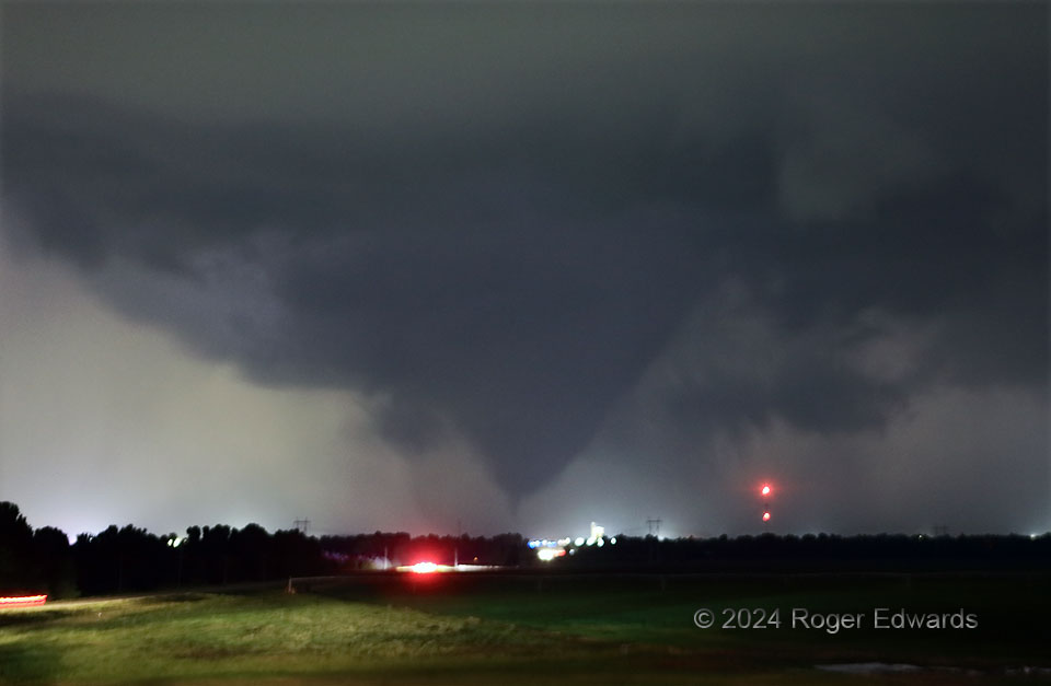
This fat-cone-with-spike shape probably was the cleanest presentation of the 2024 “Union City” nighttime tornado, from my perspective south of town and on the north-facing southern slope to the Canadian River Valley. Having stairstepped down to this spot from the northwest, in front of the long-lived, complex supercell, I chose this location specifically for the safe vantage it would have toward the two mesocyclones swirling their way about the rear flank, with potential for in-core lightning to silhouette any tornadoes produced (this was the third…here were the first two from a newer mesocyclone!). The bright light on the highway in front of the tornado was a police car and its flashing lights, smudged together in this short time exposure. Knowing that no bright, highly visible cloud-to-ground flashes were occurring in that direction, I could aim for silhouetting the tornado against dimmer, rain-wrapped lightning behind it. That’s why the other lights also appear so bright. The key to getting the rapidly evolving tornado in clean view with one exposure, even if surrounding clouds smudge some due to their movement in ambient glow, is high ISO in “bulb” setting, open aperture (somewhat low f-stop) and and releasing the shutter as soon as any flash happens behind it. This tornado, oddly, would move mainly westward from here through its dissipation phase. That’s because it occurred in an old mesocyclone that had been deeply occluded and was being shed out the back end of the storm. As such, its lifespan was limited, regardless. Fortunately, despite its seeming closeness to the town lights (a function of some zooming here) the tornado remained north of Union City and caused no casualties.
2 NNE Minco OK (19 May 24) Looking NNW
35.3393, -97.9337