 As they often tend to do, a heavy-precipitation supercell became outflow-dominant and started to evolve into a severe, forward-propagating mass of wind and rain. In the transitional phase, some structural features of the supercell remained, such as the midlevel cloud deck and tail feature above, with strong inflow still feeding the storm and its low-pressure area. Meanwhile, a fierce undercurrent of outflow surged out from the core, spawning the unfriendly looking shelf cloud below, and some certifiably severe wind several miles farther east. This storm soon would produce measured gusts of 60 kt (69 mph) at Hutchinson. Separate estimates of 90-mph winds there were overblown (pun intended), given those actual measurements and my own presence in town to affirm that the winds never got that strong. Excited or frightened amateur observers easily can overestimate severe gusts, given their limited direct experience in them, and their lack of personal calibration with proximal, instrument-sampled winds of high speed. Several years later, I led a formal scientific study of the thunderstorm-wind (over)estimation phenomenon, published in the Journal of Applied Meteorology and Climatology, partly motivated by this event (among many others), and freely available here.
1 SW Arlington KS (15 Jun 9) Looking NW
37.8862, -98.2005
As they often tend to do, a heavy-precipitation supercell became outflow-dominant and started to evolve into a severe, forward-propagating mass of wind and rain. In the transitional phase, some structural features of the supercell remained, such as the midlevel cloud deck and tail feature above, with strong inflow still feeding the storm and its low-pressure area. Meanwhile, a fierce undercurrent of outflow surged out from the core, spawning the unfriendly looking shelf cloud below, and some certifiably severe wind several miles farther east. This storm soon would produce measured gusts of 60 kt (69 mph) at Hutchinson. Separate estimates of 90-mph winds there were overblown (pun intended), given those actual measurements and my own presence in town to affirm that the winds never got that strong. Excited or frightened amateur observers easily can overestimate severe gusts, given their limited direct experience in them, and their lack of personal calibration with proximal, instrument-sampled winds of high speed. Several years later, I led a formal scientific study of the thunderstorm-wind (over)estimation phenomenon, published in the Journal of Applied Meteorology and Climatology, partly motivated by this event (among many others), and freely available here.
1 SW Arlington KS (15 Jun 9) Looking NW
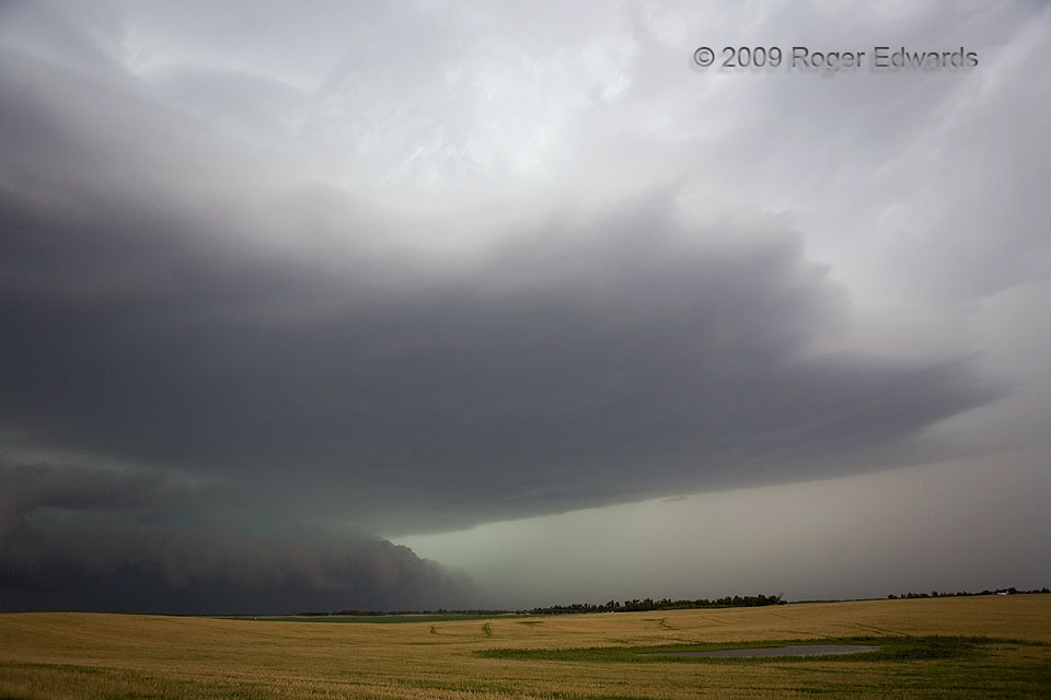
37.8862, -98.2005Severe Wind Soon
As they often tend to do, a heavy-precipitation supercell became outflow-dominant and started to evolve into a severe, forward-propagating mass of wind and rain. In the transitional phase, some structural features of the supercell remained, such as the midlevel cloud deck and tail feature above, with strong inflow still feeding the storm and its low-pressure area. Meanwhile, a fierce undercurrent of outflow surged out from the core, spawning the unfriendly looking shelf cloud below, and some certifiably severe wind several miles farther east. This storm soon would produce measured gusts of 60 kt (69 mph) at Hutchinson. Separate estimates of 90-mph winds there were overblown (pun intended), given those actual measurements and my own presence in town to affirm that the winds never got that strong. Excited or frightened amateur observers easily can overestimate severe gusts, given their limited direct experience in them, and their lack of personal calibration with proximal, instrument-sampled winds of high speed. Several years later, I led a formal scientific study of the thunderstorm-wind (over)estimation phenomenon, published in the Journal of Applied Meteorology and Climatology, partly motivated by this event (among many others), and freely available here.
1 SW Arlington KS (15 Jun 9) Looking NW
37.8862, -98.2005