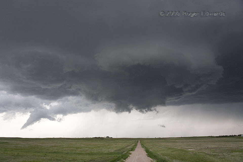
 After producing a scenic tube in Wyoming, this supercell spun across the western plains of Nebraska for several hours, threatening on a few occasions to spin up another tornado. This probably was the closet such attempt to succeeding, when a vigorously rotating wall cloud passed above the rolling wheat fields of central Banner County. The near-tornado, however, was from an old, occluded mesocyclone, tucked deeply behind (NW of) the primary wall cloud! Notice the spike-shaped formation at distant left. That was a slowly rotating funnel which dangled from the same area for several minutes before breaking apart. For an observer standing back there, transfixed by the newer circulation and not looking overhead, it could be a perilous situation. The lesson for the spotter: awareness…eyes on a swivel! The storm would assume a more heavy-precip (HP) character soon thereafter.
6 SSE Harrisburg NE (5 Jun 9) Looking N
41.4804, -103.687
After producing a scenic tube in Wyoming, this supercell spun across the western plains of Nebraska for several hours, threatening on a few occasions to spin up another tornado. This probably was the closet such attempt to succeeding, when a vigorously rotating wall cloud passed above the rolling wheat fields of central Banner County. The near-tornado, however, was from an old, occluded mesocyclone, tucked deeply behind (NW of) the primary wall cloud! Notice the spike-shaped formation at distant left. That was a slowly rotating funnel which dangled from the same area for several minutes before breaking apart. For an observer standing back there, transfixed by the newer circulation and not looking overhead, it could be a perilous situation. The lesson for the spotter: awareness…eyes on a swivel! The storm would assume a more heavy-precip (HP) character soon thereafter.
6 SSE Harrisburg NE (5 Jun 9) Looking N
41.4804, -103.687Separate Funnel Back There
 After producing a scenic tube in Wyoming, this supercell spun across the western plains of Nebraska for several hours, threatening on a few occasions to spin up another tornado. This probably was the closet such attempt to succeeding, when a vigorously rotating wall cloud passed above the rolling wheat fields of central Banner County. The near-tornado, however, was from an old, occluded mesocyclone, tucked deeply behind (NW of) the primary wall cloud! Notice the spike-shaped formation at distant left. That was a slowly rotating funnel which dangled from the same area for several minutes before breaking apart. For an observer standing back there, transfixed by the newer circulation and not looking overhead, it could be a perilous situation. The lesson for the spotter: awareness…eyes on a swivel! The storm would assume a more heavy-precip (HP) character soon thereafter.
6 SSE Harrisburg NE (5 Jun 9) Looking N
41.4804, -103.687