SkyPix

A digital photographic storybook of clouds, weather and water by Roger Edwards.

  • Home
  • Newest Posts
  • Galleries
    • Aerial
    • All Hail
    • Burnscapes
    • Daytime Lightning
    • Floods
    • Fog and Mist
    • Gallery of Outflow
    • Hurricane Andrew
    • Mini Cloud Atlas
    • Night Lightning
    • Mostly Okie Winters
    • Sunsets and Sunrises
    • The Majestic Supercell
    • Tornadoes
    • Unusual Weather Damage
    • Visual Effects
    • Wall Cloud Wall
    • Water Works
  • About
  • F.A.Q.
  • Contact

Satellite Tornado, Chickasha

2019-05-03 By Roger Edwards

Satellite Tornado, Chickasha (3 May 99)

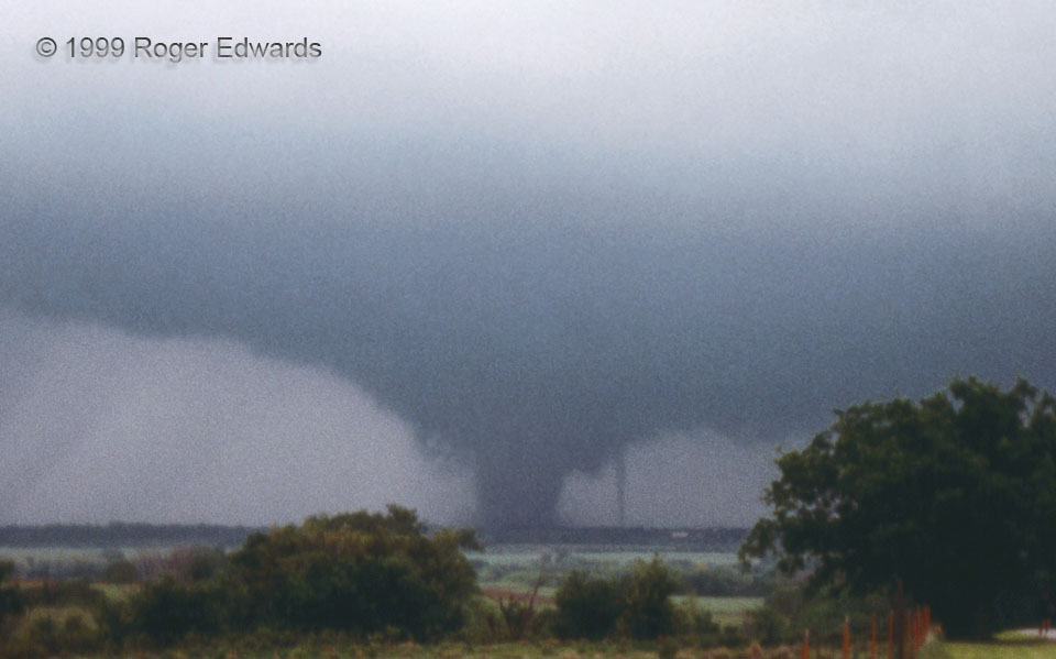
As the major Chickasha tornado and its massive, parent supercell crossed the western outskirts of town, a second, separate and much smaller tornado formed to its east (right). Two at once, in the same mesocyclone! We were stunned to see this happen, but also fascinated as scientists by the process, and very fortunate to be able to witness such an uncommon event. The big tornado was obviously dominant; so the satellite vortex moved swiftly around it in a counterclockwise sense, sometimes exceeding a 60 mph groundspeed. In this zoom, the small tornado is to its east-northeast (right). Within less then 10 seconds, it would move behind (northwest of) the main tornado, before re-emerging to the main tornado’s left (west through southwest). Both tornadoes soon dissipated, followed by the formation of the huge and violent Bridge Creek/Moore tornado. This example, and another satellite tornado (accompanying a huge EF5 wedge) that I would witness 12 years later, motivated me to compile a research database on satellite tornadoes. The 3 May 1999 outbreak was unusual in many ways, including its profusion of satellite tornadoes. This was the first of at least three such tornado pairs, as mapped here.

2 SSE Norge OK (3 May 99) Looking NW
34.9544, -97.9878

RADAR

Filed Under: Tornadoes Tagged With: Chickasha, clouds, convection, Norge, Oklahoma, satellite tornado, storms, supercells, thunderstorms, tornado, weather

Previous: Occluded and Secluded
Next: Multiple Vortices near Minco

About

Welcome to SkyPix, an online photo book of clouds, weather and water by Roger Edwards. As in a printed coffee-table book, every image has its own page with a unique story. After all, meaningful photography is much more than just picture-taking; it is visually rendering a moment in place and time from a perspective like none other. As a scientist and an artist, I hope my deep passion for the power and splendor of our skies and waters shines through in these pages. If you are a cloud and weather aficionado, outdoor enthusiast, outdoor or nature photographer, art lover, or anyone who craves learning, enjoy...

More

Further images from this photographer may be found at:
Roger Edwards Image of the Week
Roger Edwards Digital Galleries
Storms Observed Chase BLOG

Copyright © 2025 ROGER EDWARDS SKYPIX.PHOTOGRAPHY ALL RIGHTS RESERVED. · Design by INSOJOURN Design and Images · WordPress · Log in