SkyPix

A digital photographic storybook of clouds, weather and water by Roger Edwards.

  • Home
  • Newest Posts
  • Galleries
    • Aerial
    • All Hail
    • Burnscapes
    • Daytime Lightning
    • Floods
    • Fog and Mist
    • Gallery of Outflow
    • Hurricane Andrew
    • Mini Cloud Atlas
    • Night Lightning
    • Mostly Okie Winters
    • Sunsets and Sunrises
    • The Majestic Supercell
    • Tornadoes
    • Unusual Weather Damage
    • Visual Effects
    • Wall Cloud Wall
    • Water Works
  • About
  • F.A.Q.
  • Contact

Remnant Mesocyclone

2024-04-04 By Roger Edwards

Remnant Mesocyclone

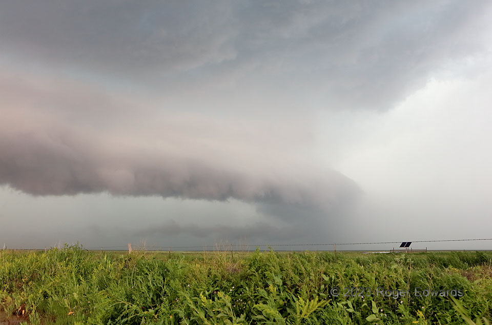
Sometimes, tracking storms in the field is far more indirect than expected.  Headed northwest from Dalhart, then west near the Oklahoma line for an intensifying supercell dropping SE from the Oklahoma Panhandle, we were moving toward ideal position to observe, but still in sun and barely too distant to see more than murky darkness under the anvil.  Cresting the hill of the heretofore good dirt road, I saw at the bottom about a mile down…a quarter-mile-long strip of deeply rutted mud and water puddles sparkling in the sunshine, with a couple vehicles stuck (and receiving help from locals).   It had been a wet spring in those parts, and such a quagmire was a definite no-go.  To get back near the original target position, I had to drive back east, southeast, west, northwest, and north for about 40 road miles, missing a brief, fuzzy tornado by less than ten minutes.  That was far from the first time something like that has happened, too!  By the time the tortuous circuit was finished, the storm had moved about 15 miles and was accelerating, as its weakly tornadic youth evolved into outflow-surfing, heavy-precipitation maturity.  We would stairstep southeastward across much of the Panhandle through the rest of the day to stay ahead of this storm and observe its successors.  The last remains of the tornadic mesocyclone are visible here behind the right edge of its intervening, rear-flank gust front’s shelf cloud, with a lower-level tail cloud still feeding in.  Despite the somewhat murky mess, this storm had an ethereal beauty to it that I appreciated, but just for a few minutes until the core got too close and sent us back equatorward.

10 NNE Perico TX (13 Jun 23) Looking NW
36.4147, -102.7971

Filed Under: Gallery of Outflow, The Majestic Supercell Tagged With: arcus, clouds, convection, Great Plains, landscapes, outflow, Perico, scud, storms, supercells, tail cloud, Texas, Texas Panhandle, thunderstorms, weather

Previous: Behind the Line
Next: M.U.N. Supercell

About

Welcome to SkyPix, an online photo book of clouds, weather and water by Roger Edwards. As in a printed coffee-table book, every image has its own page with a unique story. After all, meaningful photography is much more than just picture-taking; it is visually rendering a moment in place and time from a perspective like none other. As a scientist and an artist, I hope my deep passion for the power and splendor of our skies and waters shines through in these pages. If you are a cloud and weather aficionado, outdoor enthusiast, outdoor or nature photographer, art lover, or anyone who craves learning, enjoy...

More

Further images from this photographer may be found at:
Roger Edwards Image of the Week
Roger Edwards Digital Galleries
Storms Observed Chase BLOG

Copyright © 2025 ROGER EDWARDS SKYPIX.PHOTOGRAPHY ALL RIGHTS RESERVED. · Design by INSOJOURN Design and Images · WordPress · Log in