SkyPix

A digital photographic storybook of clouds, weather and water by Roger Edwards.

  • Home
  • Newest Posts
  • Galleries
    • Aerial
    • All Hail
    • Burnscapes
    • Daytime Lightning
    • Floods
    • Fog and Mist
    • Gallery of Outflow
    • Hurricane Andrew
    • Mini Cloud Atlas
    • Night Lightning
    • Mostly Okie Winters
    • Sunsets and Sunrises
    • The Majestic Supercell
    • Tornadoes
    • Unusual Weather Damage
    • Visual Effects
    • Wall Cloud Wall
    • Water Works
  • About
  • F.A.Q.
  • Contact

Ragged Tornado and Accessory Vortex

2019-02-21 By Roger Edwards

Ragged Tornado and Accessory Vortex

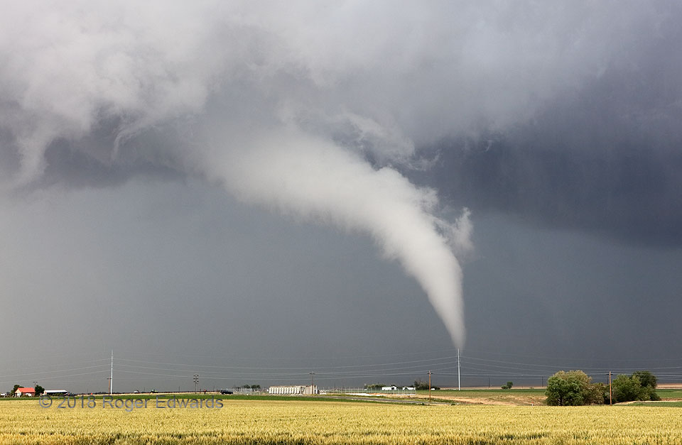
Before slowly elongating into its “white snake” stage, the Prospect Valley tornado exhibited some behavior that was uncommon in my experience for a tornado not rotating particularly fast above the surface. For once, the fuzzy, ragged cloud material along the near left “edge” of the visible funnel were forming in place and rising nearly vertically, connecting with the main condensation tube. This signified air being drawn vertically from outside the vortex, many hundreds of feet above the surface. Also, a short, narrow accessory vortex (which was spinning rather rapidly!) can be seen off the near upper-left edge of the main tube, its visual bottom directly above the top of the leftmost utility pole. This meant both funnels were pointed at electric poles, from my perspective. The only other tornadoes I have seen with well-defined accessory vortices were certifiably violent; this was not. I propose that the near-tornadic flow enhancement combined with winds of the ambient mesocyclonic updraft to stretch some pre-existing vorticity at that level in order to form the visible secondary funnel, which did not connected to the main tornado (unless at a position hidden in the ambient cloud mass above), and which only lasted a few more seconds.

4 S Prospect Valley CO (19 Jun 18) Looking NNE
40.0152, -104.4178

Filed Under: Tornadoes Tagged With: accessory vortex, clouds, Colorado, convection, Great Plains, landscapes, Prospect Valley, storms, supercells, thunderstorms, tornado, weather

Previous: Morning in the Keys
Next: Papakolea “Green Sand” Beach Cliffs

About

Welcome to SkyPix, an online photo book of clouds, weather and water by Roger Edwards. As in a printed coffee-table book, every image has its own page with a unique story. After all, meaningful photography is much more than just picture-taking; it is visually rendering a moment in place and time from a perspective like none other. As a scientist and an artist, I hope my deep passion for the power and splendor of our skies and waters shines through in these pages. If you are a cloud and weather aficionado, outdoor enthusiast, outdoor or nature photographer, art lover, or anyone who craves learning, enjoy...

More

Further images from this photographer may be found at:
Roger Edwards Image of the Week
Roger Edwards Digital Galleries
Storms Observed Chase BLOG

Copyright © 2025 ROGER EDWARDS SKYPIX.PHOTOGRAPHY ALL RIGHTS RESERVED. · Design by INSOJOURN Design and Images · WordPress · Log in