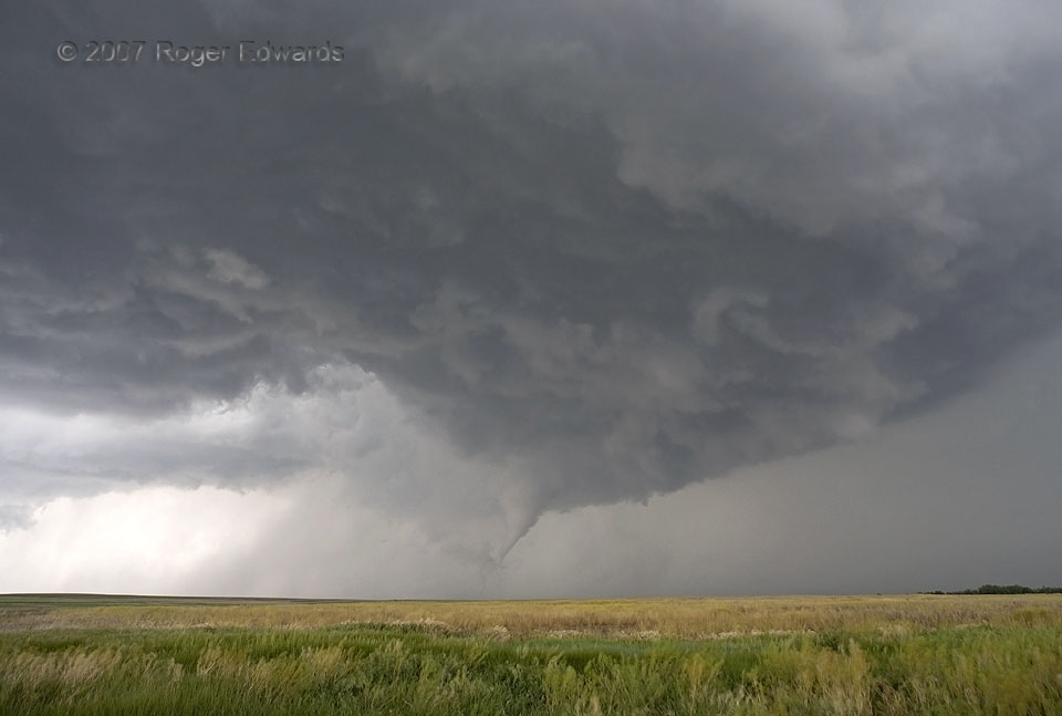
 That title is true. This storm intercept was logistically smooth and conformed well to my pre-departure forecast, with a few positively reinforcing nowcast calls from Elke and from Matt Biddle (pre-“smartphone” era). Those factors allowed me to drive 250 miles right to the storm initiation zone, then to track visually—with no onboard radar—early towers evolving into a well-structured supercell at a comfortable distance. The tornado was atypically easy to view and photograph, from a hilltop, with a fine western Kansas field in the foreground. No other storm chasers were parked on the side road that I happened to choose, when it seemed that tornadogenesis was imminent. [There were a lot of vehicles on the main highway, just beyond those trees at right.] Best of all, the tornado lasted several minutes in open country, harming nobody. Wrapping rain eroded away, instead of following the usual trend of thickening through a tornado’s lifespan. All that made this wide-angle view possible. It can’t get much better for a storm observer. The condensation vortex soon would “rope out” in a fascinating and enjoyable way as well.
11 E St. Peter KS (22 May 7) Looking NNE
39.1903, -99.8847
That title is true. This storm intercept was logistically smooth and conformed well to my pre-departure forecast, with a few positively reinforcing nowcast calls from Elke and from Matt Biddle (pre-“smartphone” era). Those factors allowed me to drive 250 miles right to the storm initiation zone, then to track visually—with no onboard radar—early towers evolving into a well-structured supercell at a comfortable distance. The tornado was atypically easy to view and photograph, from a hilltop, with a fine western Kansas field in the foreground. No other storm chasers were parked on the side road that I happened to choose, when it seemed that tornadogenesis was imminent. [There were a lot of vehicles on the main highway, just beyond those trees at right.] Best of all, the tornado lasted several minutes in open country, harming nobody. Wrapping rain eroded away, instead of following the usual trend of thickening through a tornado’s lifespan. All that made this wide-angle view possible. It can’t get much better for a storm observer. The condensation vortex soon would “rope out” in a fascinating and enjoyable way as well.
11 E St. Peter KS (22 May 7) Looking NNE
39.1903, -99.8847Pleasant Little Tornado
 That title is true. This storm intercept was logistically smooth and conformed well to my pre-departure forecast, with a few positively reinforcing nowcast calls from Elke and from Matt Biddle (pre-“smartphone” era). Those factors allowed me to drive 250 miles right to the storm initiation zone, then to track visually—with no onboard radar—early towers evolving into a well-structured supercell at a comfortable distance. The tornado was atypically easy to view and photograph, from a hilltop, with a fine western Kansas field in the foreground. No other storm chasers were parked on the side road that I happened to choose, when it seemed that tornadogenesis was imminent. [There were a lot of vehicles on the main highway, just beyond those trees at right.] Best of all, the tornado lasted several minutes in open country, harming nobody. Wrapping rain eroded away, instead of following the usual trend of thickening through a tornado’s lifespan. All that made this wide-angle view possible. It can’t get much better for a storm observer. The condensation vortex soon would “rope out” in a fascinating and enjoyable way as well.
11 E St. Peter KS (22 May 7) Looking NNE
39.1903, -99.8847