 For hours, this dryline-born storm puttered erratically north-northeastward across the Texas and Oklahoma Panhandles as a high-based multicell and weak supercell, seemingly allergic to the concept of robust organization. We got disgusted by its poor structure and seeming impotence in spite of favorable deep shear, and left just before sunset to aim for the next day’s presumed target area in southern Nebraska to northern Kansas (which didn’t pan out). Fortunately, still within hazy sight distance after turning away, my glance in the rear-view mirror revealed a scene vastly different than what we had just left: a broadly based supercell with huge, thick, overturning convective towers! The earliest fragment of the low-level jet had started to kick in before sunset, boosting low-level shear and moisture just enough to do the trick. The tornado, seen from close-range by longtime friend and storm observer Jim Leonard, had prompted him to yell on his video, “Oklahoma Panhandle did it today!” We pulled northward several miles to keep abeam, pulled over, and saw the tornado develop in the distance, followed several minutes later by a separate nontornadic funnel. This was my first tornado seen on a storm chase, after almost five years and nearly 60 tries. A later occlusion from the same supercell offered three additional, closer, post-sunset tornadoes in low light, just over the Colorado state line.
9 NNE Keyes OK (11 May 91) Looking W
36.9458, -102.2268
For hours, this dryline-born storm puttered erratically north-northeastward across the Texas and Oklahoma Panhandles as a high-based multicell and weak supercell, seemingly allergic to the concept of robust organization. We got disgusted by its poor structure and seeming impotence in spite of favorable deep shear, and left just before sunset to aim for the next day’s presumed target area in southern Nebraska to northern Kansas (which didn’t pan out). Fortunately, still within hazy sight distance after turning away, my glance in the rear-view mirror revealed a scene vastly different than what we had just left: a broadly based supercell with huge, thick, overturning convective towers! The earliest fragment of the low-level jet had started to kick in before sunset, boosting low-level shear and moisture just enough to do the trick. The tornado, seen from close-range by longtime friend and storm observer Jim Leonard, had prompted him to yell on his video, “Oklahoma Panhandle did it today!” We pulled northward several miles to keep abeam, pulled over, and saw the tornado develop in the distance, followed several minutes later by a separate nontornadic funnel. This was my first tornado seen on a storm chase, after almost five years and nearly 60 tries. A later occlusion from the same supercell offered three additional, closer, post-sunset tornadoes in low light, just over the Colorado state line.
9 NNE Keyes OK (11 May 91) Looking W
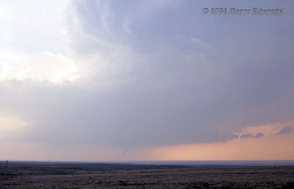
36.9458, -102.2268Oklahoma Panhandle Did It Today!
For hours, this dryline-born storm puttered erratically north-northeastward across the Texas and Oklahoma Panhandles as a high-based multicell and weak supercell, seemingly allergic to the concept of robust organization. We got disgusted by its poor structure and seeming impotence in spite of favorable deep shear, and left just before sunset to aim for the next day’s presumed target area in southern Nebraska to northern Kansas (which didn’t pan out). Fortunately, still within hazy sight distance after turning away, my glance in the rear-view mirror revealed a scene vastly different than what we had just left: a broadly based supercell with huge, thick, overturning convective towers! The earliest fragment of the low-level jet had started to kick in before sunset, boosting low-level shear and moisture just enough to do the trick. The tornado, seen from close-range by longtime friend and storm observer Jim Leonard, had prompted him to yell on his video, “Oklahoma Panhandle did it today!” We pulled northward several miles to keep abeam, pulled over, and saw the tornado develop in the distance, followed several minutes later by a separate nontornadic funnel. This was my first tornado seen on a storm chase, after almost five years and nearly 60 tries. A later occlusion from the same supercell offered three additional, closer, post-sunset tornadoes in low light, just over the Colorado state line.
9 NNE Keyes OK (11 May 91) Looking W
36.9458, -102.2268