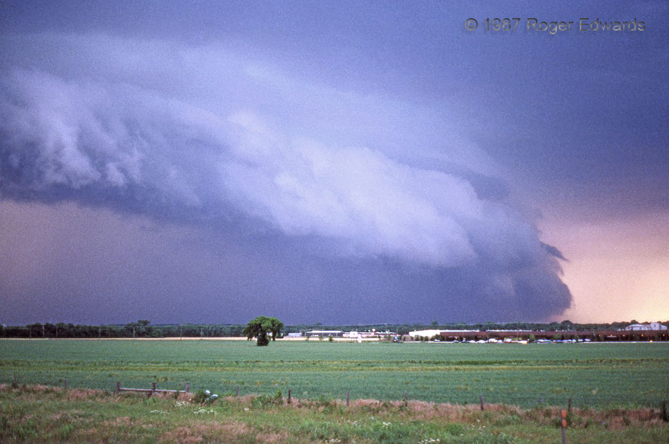
 In this scan from the era’s somewhat grainy Ektachrome film (I was lucky to afford that as a college student!), a large, thick arcus thrusts eastward from the forward-flank gust front of an HP (heavy-precip) supercell. Note greenish tint in the notch between the top of the arcus and the cloud base above it. The funnel-like horizontal cloud filament on the leading edge of the arcus was rotating, which is unusual for horizontal features on shelf-cloud faces. The parent thunderstorm, an outflow-dominant supercell, pounded a NSSL chase vehicle with baseball size hail at Yukon, OK, at this time. The green field on the foreground today is paved over, filled with several chain restaurants and a Wal-Mart, and their parking lots. Meanwhile the OKC metro has filled in entirely through Yukon and beyond. The same supercell today would render far greater economic losses!
Oklahoma City OK (21 May 87) Looking NW
35.4604, -97.6195
In this scan from the era’s somewhat grainy Ektachrome film (I was lucky to afford that as a college student!), a large, thick arcus thrusts eastward from the forward-flank gust front of an HP (heavy-precip) supercell. Note greenish tint in the notch between the top of the arcus and the cloud base above it. The funnel-like horizontal cloud filament on the leading edge of the arcus was rotating, which is unusual for horizontal features on shelf-cloud faces. The parent thunderstorm, an outflow-dominant supercell, pounded a NSSL chase vehicle with baseball size hail at Yukon, OK, at this time. The green field on the foreground today is paved over, filled with several chain restaurants and a Wal-Mart, and their parking lots. Meanwhile the OKC metro has filled in entirely through Yukon and beyond. The same supercell today would render far greater economic losses!
Oklahoma City OK (21 May 87) Looking NW
35.4604, -97.6195Oklahoma City Arcus
 In this scan from the era’s somewhat grainy Ektachrome film (I was lucky to afford that as a college student!), a large, thick arcus thrusts eastward from the forward-flank gust front of an HP (heavy-precip) supercell. Note greenish tint in the notch between the top of the arcus and the cloud base above it. The funnel-like horizontal cloud filament on the leading edge of the arcus was rotating, which is unusual for horizontal features on shelf-cloud faces. The parent thunderstorm, an outflow-dominant supercell, pounded a NSSL chase vehicle with baseball size hail at Yukon, OK, at this time. The green field on the foreground today is paved over, filled with several chain restaurants and a Wal-Mart, and their parking lots. Meanwhile the OKC metro has filled in entirely through Yukon and beyond. The same supercell today would render far greater economic losses!
Oklahoma City OK (21 May 87) Looking NW
35.4604, -97.6195