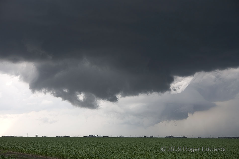
 This storm already had produced a couple of tornadoes distantly visible to us, but seemed resigned to nontornadic occlusions by the time we closed in for more intimate observation. This mesocyclonic handoff may have been the most fascinating, because it presented perhaps the most striking example of old and new occlusions I’ve seen in a supercell. The old mesocyclone (right background) retreated to the back (W) side of the storm, but developed its own bell-shaped structure, complete with ragged wall cloud and fuzzy, rotating lowering strongly resembling a ragged funnel. It almost seemed to be a supercell unto itself, cast aside by the storm at large. The newer wall cloud at front already was being cut by a clear slot, another in a series of circulations spanning a long time gap between the storm’s two tornado-producing phases. Things would get more exciting again in another hour or so, after the storm shed a few more short-lived mesocyclonic cycles and renewed its tornadic offerings.
1 SW Alda NE (17 Jun 9) Looking NW
40.8601, -98.4932
This storm already had produced a couple of tornadoes distantly visible to us, but seemed resigned to nontornadic occlusions by the time we closed in for more intimate observation. This mesocyclonic handoff may have been the most fascinating, because it presented perhaps the most striking example of old and new occlusions I’ve seen in a supercell. The old mesocyclone (right background) retreated to the back (W) side of the storm, but developed its own bell-shaped structure, complete with ragged wall cloud and fuzzy, rotating lowering strongly resembling a ragged funnel. It almost seemed to be a supercell unto itself, cast aside by the storm at large. The newer wall cloud at front already was being cut by a clear slot, another in a series of circulations spanning a long time gap between the storm’s two tornado-producing phases. Things would get more exciting again in another hour or so, after the storm shed a few more short-lived mesocyclonic cycles and renewed its tornadic offerings.
1 SW Alda NE (17 Jun 9) Looking NW
40.8601, -98.4932Occlusions Old and New
 This storm already had produced a couple of tornadoes distantly visible to us, but seemed resigned to nontornadic occlusions by the time we closed in for more intimate observation. This mesocyclonic handoff may have been the most fascinating, because it presented perhaps the most striking example of old and new occlusions I’ve seen in a supercell. The old mesocyclone (right background) retreated to the back (W) side of the storm, but developed its own bell-shaped structure, complete with ragged wall cloud and fuzzy, rotating lowering strongly resembling a ragged funnel. It almost seemed to be a supercell unto itself, cast aside by the storm at large. The newer wall cloud at front already was being cut by a clear slot, another in a series of circulations spanning a long time gap between the storm’s two tornado-producing phases. Things would get more exciting again in another hour or so, after the storm shed a few more short-lived mesocyclonic cycles and renewed its tornadic offerings.
1 SW Alda NE (17 Jun 9) Looking NW
40.8601, -98.4932