SkyPix

A digital photographic storybook of clouds, weather and water by Roger Edwards.

  • Home
  • Newest Posts
  • Galleries
    • Aerial
    • All Hail
    • Burnscapes
    • Daytime Lightning
    • Floods
    • Fog and Mist
    • Gallery of Outflow
    • Hurricane Andrew
    • Mini Cloud Atlas
    • Night Lightning
    • Mostly Okie Winters
    • Sunsets and Sunrises
    • The Majestic Supercell
    • Tornadoes
    • Unusual Weather Damage
    • Visual Effects
    • Wall Cloud Wall
    • Water Works
  • About
  • F.A.Q.
  • Contact

Occlusion Attention: Part 2

2021-10-02 By Roger Edwards

Occlusion Attention: Part 2

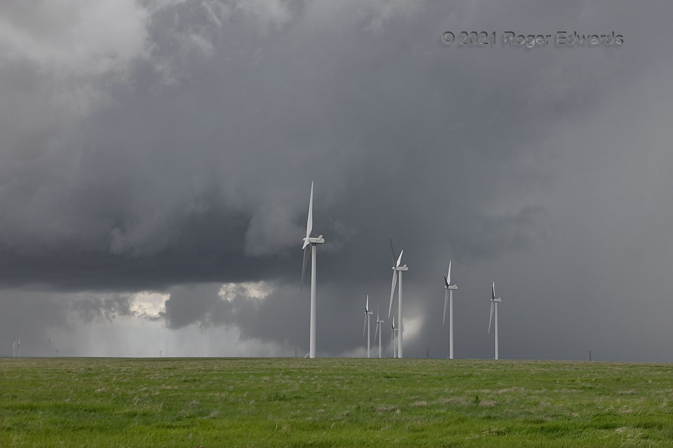
After this supercell’s forward-flank core and rain foot shifted northward enough to see the rotating, deeply occluded wall cloud in the distance, I tried to pay very close attention to the area under it, while not losing track of the closer, main updraft base (also rotating, but very slowly at this point).  The slightly higher terrain, upon which the wind turbines sat, didn’t help, nor did the wind equipment itself—distracting and obscuring, breaking visual continuity.  Yet this was a relative high spot accessible from the highway, and no better view was available nearby.  The low and fuzzy base rotated, maybe with brief vortex filaments beneath.  The most persistent and suspicious lowering was a persistent, conical feature at right, behind the very tip of the rain foot, seen behind and in between distant middle turbines.  The lowering moved right (north) then left (southwest and south), clearly orbiting the north rim of the mesocyclone.  Was it tornadic?  I can’t tell you for sure.  There was just enough terrain obscuration, distance, and continuity interruption by the turbine poles, to keep me from ascertaining more-concentrated rotation in the feature.  Wind farms can impede storm spotting!  It also occurred in a roadless, remote area with nothing to damage structurally—indeed, little more exists out there than grass, sagebrush, and jackrabbits.  Yet the lowering would persist and evolve… [Go to Part 3]

16 NNE Limon CO (23 May 21) Looking SW
39.5127, -103.6218

Filed Under: Wall Cloud Wall Tagged With: clouds, Colorado, convection, landscapes; Great Plains, Last Chance, Limon, scud, storms, supercells, thunderstorms, wall clouds, weather, wind farm

Previous: Occlusion Attention: Part 1
Next: Occlusion Attention: Part 3

About

Welcome to SkyPix, an online photo book of clouds, weather and water by Roger Edwards. As in a printed coffee-table book, every image has its own page with a unique story. After all, meaningful photography is much more than just picture-taking; it is visually rendering a moment in place and time from a perspective like none other. As a scientist and an artist, I hope my deep passion for the power and splendor of our skies and waters shines through in these pages. If you are a cloud and weather aficionado, outdoor enthusiast, outdoor or nature photographer, art lover, or anyone who craves learning, enjoy...

More

Further images from this photographer may be found at:
Roger Edwards Image of the Week
Roger Edwards Digital Galleries
Storms Observed Chase BLOG

Copyright © 2025 ROGER EDWARDS SKYPIX.PHOTOGRAPHY ALL RIGHTS RESERVED. · Design by INSOJOURN Design and Images · WordPress · Log in