SkyPix

A digital photographic storybook of clouds, weather and water by Roger Edwards.

  • Home
  • Newest Posts
  • Galleries
    • Aerial
    • All Hail
    • Burnscapes
    • Daytime Lightning
    • Floods
    • Fog and Mist
    • Gallery of Outflow
    • Hurricane Andrew
    • Mini Cloud Atlas
    • Night Lightning
    • Mostly Okie Winters
    • Sunsets and Sunrises
    • The Majestic Supercell
    • Tornadoes
    • Unusual Weather Damage
    • Visual Effects
    • Wall Cloud Wall
    • Water Works
  • About
  • F.A.Q.
  • Contact

Night Mesocyclone: Convergent, Rising Dust

2024-10-15 By Roger Edwards

Night Mesocyclone:  Convergent, Rising Dust

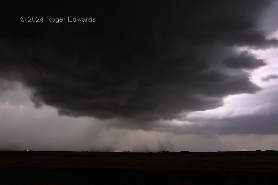
A long day of driving up from Norman, and observing spectacular supercells mainly in Nebraska, concluded on the way to my motel room at night, with another one forming along a trailing part of the same outflow-reinforced baroclinic zone.  Staring straight under the mesocyclone and wall cloud here, with a formidable rear-flank core at left, and given the stabilizing inflow layer, I knew this storm would have a limited window to produce a tornado, if at all.  The synoptic to mesoscale environment was only marginally favorable, yet this mesocyclone tried hard, drawing up convergent dust columns from both the inflow region (right) and rear-flank gust front (left).   Cloud-base cyclonic shear was broad and not very strong, however, as ascertained by following individual lowerings through nearly continual in-cloud lightning, and the dust was rising and converging far more than rotating (if at all).  Verdict: nontornadic!  Regardless, the mesocyclonic updraft was moving my way, and still obviously surface-based, compelling me to get out of its way shortly.

3 N Lebanon KS (7 Jun 24) Looking NW
39.8574, -98.5529


Filed Under: Wall Cloud Wall Tagged With: clouds, convection, dust, Great Plains, Kansas, Lebanon, lightning, nighttime, scud, storms, supercells, thunderstorms, wall clouds, weather

Previous: Rainier in Sunrise
Next: Turquoise Divider

About

Welcome to SkyPix, an online photo book of clouds, weather and water by Roger Edwards. As in a printed coffee-table book, every image has its own page with a unique story. After all, meaningful photography is much more than just picture-taking; it is visually rendering a moment in place and time from a perspective like none other. As a scientist and an artist, I hope my deep passion for the power and splendor of our skies and waters shines through in these pages. If you are a cloud and weather aficionado, outdoor enthusiast, outdoor or nature photographer, art lover, or anyone who craves learning, enjoy...

More

Further images from this photographer may be found at:
Roger Edwards Image of the Week
Roger Edwards Digital Galleries
Storms Observed Chase BLOG

Copyright © 2025 ROGER EDWARDS SKYPIX.PHOTOGRAPHY ALL RIGHTS RESERVED. · Design by INSOJOURN Design and Images · WordPress · Log in