 Two hundred fifty miles back and forth for this? Why, yes! We had started the day northwest of the warm front in Kimball, needed an electronic repair nearest done in Cheyenne, WY, while forecast-targeting the northeastern corner of Colorado, northeast of a mesolow along the front where convergence should be maximized. I like challenges. High-speed-limit High Plains interstate: no problem! We ate breakfast, blasted west, got the fix done, then high-tailed it back east past where we started, but a few hours later, all at very close to posted speeds, and got around in front of this storm with just a minutes to spare, watching this chaotic but rapidly rotating mesocyclone approach the road where we just had been. “Punching the core” was not as stupid as usual, and was done calculatingly with meteorology in mind! Remnants of an eastern Pacific tropical cyclone had spread a plume of midlevel moisture, warm midlevel temperatures, high melting levels and modest lapse rates aloft over the area, lessening the typical north-of-hook damaging-hail risk markedly, but with moisture and shear in low levels still rotation-favorable. Indeed, the biggest hail we hit in the core was pea size, and I knew where the mesocyclone was. So here we landed—observing inflow dust, outflow dust, dust mixed with rain rotating at the rate of the circulation but not at tornadic speeds, and wild motions all around. The storm was every bit the whirling dervish of chaos that it appears, along the Colorado/Nebraska line northeast of Julesburg, but would go on to produce a brief, low-contrast, rain-wrapped tornado north of Big Springs while we were driving.
9 WSW Big Springs NE (17 Jun 18) Looking WSW
41.0344, -102.2118
Two hundred fifty miles back and forth for this? Why, yes! We had started the day northwest of the warm front in Kimball, needed an electronic repair nearest done in Cheyenne, WY, while forecast-targeting the northeastern corner of Colorado, northeast of a mesolow along the front where convergence should be maximized. I like challenges. High-speed-limit High Plains interstate: no problem! We ate breakfast, blasted west, got the fix done, then high-tailed it back east past where we started, but a few hours later, all at very close to posted speeds, and got around in front of this storm with just a minutes to spare, watching this chaotic but rapidly rotating mesocyclone approach the road where we just had been. “Punching the core” was not as stupid as usual, and was done calculatingly with meteorology in mind! Remnants of an eastern Pacific tropical cyclone had spread a plume of midlevel moisture, warm midlevel temperatures, high melting levels and modest lapse rates aloft over the area, lessening the typical north-of-hook damaging-hail risk markedly, but with moisture and shear in low levels still rotation-favorable. Indeed, the biggest hail we hit in the core was pea size, and I knew where the mesocyclone was. So here we landed—observing inflow dust, outflow dust, dust mixed with rain rotating at the rate of the circulation but not at tornadic speeds, and wild motions all around. The storm was every bit the whirling dervish of chaos that it appears, along the Colorado/Nebraska line northeast of Julesburg, but would go on to produce a brief, low-contrast, rain-wrapped tornado north of Big Springs while we were driving.
9 WSW Big Springs NE (17 Jun 18) Looking WSW
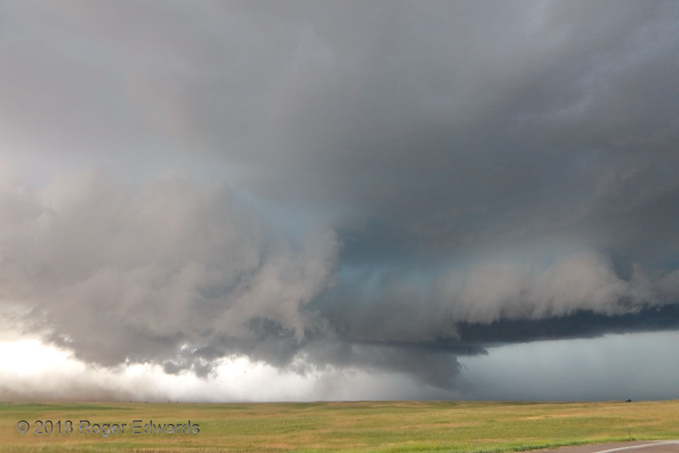
41.0344, -102.2118Messy Mesocyclone
Two hundred fifty miles back and forth for this? Why, yes! We had started the day northwest of the warm front in Kimball, needed an electronic repair nearest done in Cheyenne, WY, while forecast-targeting the northeastern corner of Colorado, northeast of a mesolow along the front where convergence should be maximized. I like challenges. High-speed-limit High Plains interstate: no problem! We ate breakfast, blasted west, got the fix done, then high-tailed it back east past where we started, but a few hours later, all at very close to posted speeds, and got around in front of this storm with just a minutes to spare, watching this chaotic but rapidly rotating mesocyclone approach the road where we just had been. “Punching the core” was not as stupid as usual, and was done calculatingly with meteorology in mind! Remnants of an eastern Pacific tropical cyclone had spread a plume of midlevel moisture, warm midlevel temperatures, high melting levels and modest lapse rates aloft over the area, lessening the typical north-of-hook damaging-hail risk markedly, but with moisture and shear in low levels still rotation-favorable. Indeed, the biggest hail we hit in the core was pea size, and I knew where the mesocyclone was. So here we landed—observing inflow dust, outflow dust, dust mixed with rain rotating at the rate of the circulation but not at tornadic speeds, and wild motions all around. The storm was every bit the whirling dervish of chaos that it appears, along the Colorado/Nebraska line northeast of Julesburg, but would go on to produce a brief, low-contrast, rain-wrapped tornado north of Big Springs while we were driving.
9 WSW Big Springs NE (17 Jun 18) Looking WSW
41.0344, -102.2118