SkyPix

A digital photographic storybook of clouds, weather and water by Roger Edwards.

  • Home
  • Newest Posts
  • Galleries
    • Aerial
    • All Hail
    • Burnscapes
    • Daytime Lightning
    • Floods
    • Fog and Mist
    • Gallery of Outflow
    • Hurricane Andrew
    • Mini Cloud Atlas
    • Night Lightning
    • Mostly Okie Winters
    • Sunsets and Sunrises
    • The Majestic Supercell
    • Tornadoes
    • Unusual Weather Damage
    • Visual Effects
    • Wall Cloud Wall
    • Water Works
  • About
  • F.A.Q.
  • Contact

Menacing Ark City

2022-12-04 By Roger Edwards

Menacing Ark City

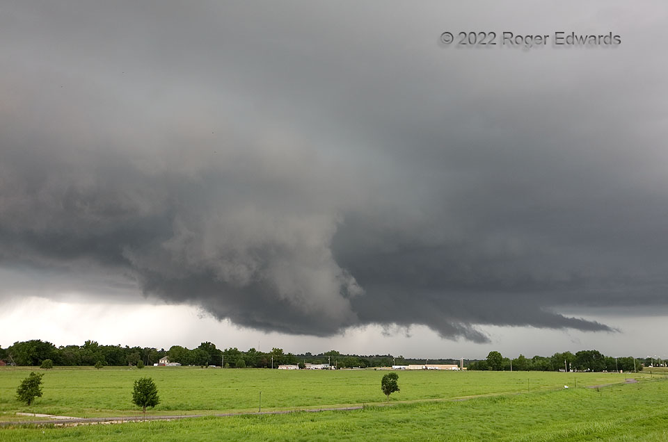
A previously unassuming, strung-out and poorly organized supercell hit a plume of greater low-level moisture and vorticity, accompanying a modified outflow boundary from the previous night’s thunderstorms.  It got happy quickly.  This wall cloud formed fast and rotated strongly.  The front-lit scud lowering in the foreground raced left to right as cloud material in the background pulled the other way, from the tail cloud that can be seen extending into the forward-flank area.   I was surprised this did not produce a tornado, but glad, as the circulation was hovering over the northern side of Arkansas City, and could have caused casualties.  The storm also was potentially deadly in another way, slamming bright, forked, close, staccato lightning all around us, every 10–15 seconds.   This meant that even the usual exercise of timing car exit for a few seconds, just after a nearby CG to take advantage of “recharge time”, was disconcertingly risky.  As such, I only got this and one similar photo of this stage.  This supercell would produce a few more fast occlusions, some rain-wrapped, before moving into the Flint Hills road hole.  Another would develop very late in the day and move along this storm’s outflow boundary, merging with yet a third in twilight.

Arkansas City KS (31 May 22) Looking NW
37.0707, -97.0261

Filed Under: Wall Cloud Wall Tagged With: Arkansas City, clouds, convection, Great Plains, Kansas, landscapes, storms, supercells, tail cloud, thunderstorms, wall clouds, weather

Previous: Busted Trees at NWC
Next: Potwin HP

About

Welcome to SkyPix, an online photo book of clouds, weather and water by Roger Edwards. As in a printed coffee-table book, every image has its own page with a unique story. After all, meaningful photography is much more than just picture-taking; it is visually rendering a moment in place and time from a perspective like none other. As a scientist and an artist, I hope my deep passion for the power and splendor of our skies and waters shines through in these pages. If you are a cloud and weather aficionado, outdoor enthusiast, outdoor or nature photographer, art lover, or anyone who craves learning, enjoy...

More

Further images from this photographer may be found at:
Roger Edwards Image of the Week
Roger Edwards Digital Galleries
Storms Observed Chase BLOG

Copyright © 2025 ROGER EDWARDS SKYPIX.PHOTOGRAPHY ALL RIGHTS RESERVED. · Design by INSOJOURN Design and Images · WordPress · Log in