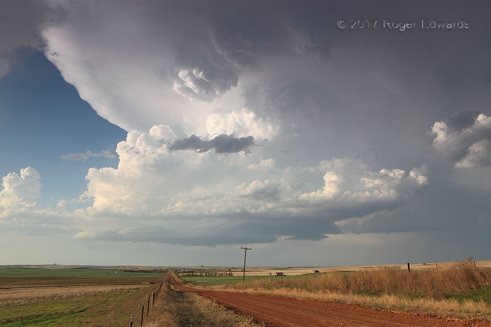
 Growing by the minute, by means of multiple, intense updraft thrusts roaring upward from an increasingly moist source layer, this young low-precipitation (LP) supercell drifted eastward parallel to (and just north of) the Oklahoma-Kansas border. Meanwhile we observed from a pleasant distance, enjoying whole-storm structural views across the rolling, red-dirt prairie. Part of that marvelous structure was a persistent area of “knuckles” at top center in this view, just upshear from where the updraft towers met the anvil. Knuckles, or “inverted convection”, are an intensely cumuliform, upside-down cloud formation, much more visually convective than mammatus. They jut down from the anvil after encountering the stratospheric stable layer, but before they descend enough to evaporate the cloud material fed by their redirected moist plume. In storm-chasing jargon, a storm (usually a supercell) with garishly large, deep examples of that formation is a “knuckle dragger”, and this example of garishly fat knuckles could be the prototype for the term! This storm would maintain at least some knuckle-popping power while turning into a sunset spectacular.
5 NNE Buffalo OK (15 Apr 17) Looking NNE
36.9073, -99.6028
Growing by the minute, by means of multiple, intense updraft thrusts roaring upward from an increasingly moist source layer, this young low-precipitation (LP) supercell drifted eastward parallel to (and just north of) the Oklahoma-Kansas border. Meanwhile we observed from a pleasant distance, enjoying whole-storm structural views across the rolling, red-dirt prairie. Part of that marvelous structure was a persistent area of “knuckles” at top center in this view, just upshear from where the updraft towers met the anvil. Knuckles, or “inverted convection”, are an intensely cumuliform, upside-down cloud formation, much more visually convective than mammatus. They jut down from the anvil after encountering the stratospheric stable layer, but before they descend enough to evaporate the cloud material fed by their redirected moist plume. In storm-chasing jargon, a storm (usually a supercell) with garishly large, deep examples of that formation is a “knuckle dragger”, and this example of garishly fat knuckles could be the prototype for the term! This storm would maintain at least some knuckle-popping power while turning into a sunset spectacular.
5 NNE Buffalo OK (15 Apr 17) Looking NNE
36.9073, -99.6028Knuckle Dragger
 Growing by the minute, by means of multiple, intense updraft thrusts roaring upward from an increasingly moist source layer, this young low-precipitation (LP) supercell drifted eastward parallel to (and just north of) the Oklahoma-Kansas border. Meanwhile we observed from a pleasant distance, enjoying whole-storm structural views across the rolling, red-dirt prairie. Part of that marvelous structure was a persistent area of “knuckles” at top center in this view, just upshear from where the updraft towers met the anvil. Knuckles, or “inverted convection”, are an intensely cumuliform, upside-down cloud formation, much more visually convective than mammatus. They jut down from the anvil after encountering the stratospheric stable layer, but before they descend enough to evaporate the cloud material fed by their redirected moist plume. In storm-chasing jargon, a storm (usually a supercell) with garishly large, deep examples of that formation is a “knuckle dragger”, and this example of garishly fat knuckles could be the prototype for the term! This storm would maintain at least some knuckle-popping power while turning into a sunset spectacular.
5 NNE Buffalo OK (15 Apr 17) Looking NNE
36.9073, -99.6028