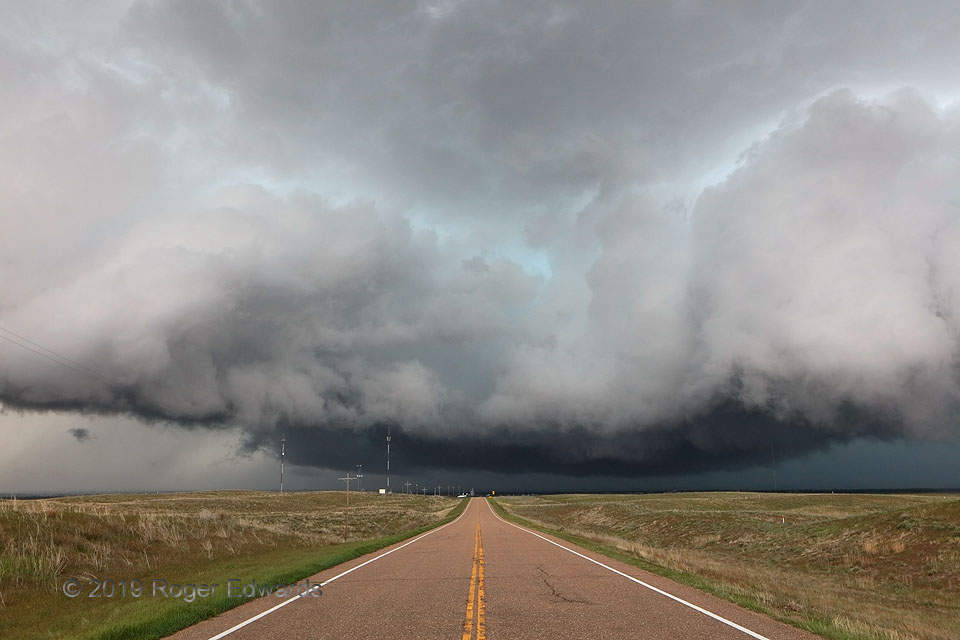
 This isn’t just a weird and ominous-looking High Plains thunderstorm. You’re staring right down the “notch” of a supercell unlike most found in weather textbooks and photo sites. This one developed within a loose band of convection, and remained what we often call a “line-embedded supercell” for most of its lifespan. The storm had a standout reflectivity and velocity presentation as a supercell for well over an hour, but also, lighter precipitation continuous for tens of miles its northeast and southwest. Based on radar at the time, the midlevel mesocyclone was nearly directly beyond the center line, and over Sterling. The updraft, bent into a boomerang shape, was manifest as these towers along its leading edge, with occasional areas of low-level rotation from dead-center of the view to nearer right. Areas of heavy rain, hail and outflow bent all around the curved updraft area, to its left (rear-flank downdraft, RFD), right (forward-flank downdraft) and behind. I was in a slot of warm, moist, surface-based inflow pointing directly down the road and into the updraft area, but soon would be overrun by cold outflow from the RFD as the storm wrapped more deeply and started to accelerate east-northeastward. It would get very murky, messy and deceptive…
4 ESE Sterling CO (27 May 19) Looking WNW
40.6076, -103.1376
This isn’t just a weird and ominous-looking High Plains thunderstorm. You’re staring right down the “notch” of a supercell unlike most found in weather textbooks and photo sites. This one developed within a loose band of convection, and remained what we often call a “line-embedded supercell” for most of its lifespan. The storm had a standout reflectivity and velocity presentation as a supercell for well over an hour, but also, lighter precipitation continuous for tens of miles its northeast and southwest. Based on radar at the time, the midlevel mesocyclone was nearly directly beyond the center line, and over Sterling. The updraft, bent into a boomerang shape, was manifest as these towers along its leading edge, with occasional areas of low-level rotation from dead-center of the view to nearer right. Areas of heavy rain, hail and outflow bent all around the curved updraft area, to its left (rear-flank downdraft, RFD), right (forward-flank downdraft) and behind. I was in a slot of warm, moist, surface-based inflow pointing directly down the road and into the updraft area, but soon would be overrun by cold outflow from the RFD as the storm wrapped more deeply and started to accelerate east-northeastward. It would get very murky, messy and deceptive…
4 ESE Sterling CO (27 May 19) Looking WNW
40.6076, -103.1376Into the Notch
This isn’t just a weird and ominous-looking High Plains thunderstorm. You’re staring right down the “notch” of a supercell unlike most found in weather textbooks and photo sites. This one developed within a loose band of convection, and remained what we often call a “line-embedded supercell” for most of its lifespan. The storm had a standout reflectivity and velocity presentation as a supercell for well over an hour, but also, lighter precipitation continuous for tens of miles its northeast and southwest. Based on radar at the time, the midlevel mesocyclone was nearly directly beyond the center line, and over Sterling. The updraft, bent into a boomerang shape, was manifest as these towers along its leading edge, with occasional areas of low-level rotation from dead-center of the view to nearer right. Areas of heavy rain, hail and outflow bent all around the curved updraft area, to its left (rear-flank downdraft, RFD), right (forward-flank downdraft) and behind. I was in a slot of warm, moist, surface-based inflow pointing directly down the road and into the updraft area, but soon would be overrun by cold outflow from the RFD as the storm wrapped more deeply and started to accelerate east-northeastward. It would get very murky, messy and deceptive…
4 ESE Sterling CO (27 May 19) Looking WNW
40.6076, -103.1376