SkyPix

A digital photographic storybook of clouds, weather and water by Roger Edwards.

  • Home
  • Newest Posts
  • Galleries
    • Aerial
    • All Hail
    • Burnscapes
    • Daytime Lightning
    • Floods
    • Fog and Mist
    • Gallery of Outflow
    • Hurricane Andrew
    • Mini Cloud Atlas
    • Night Lightning
    • Mostly Okie Winters
    • Sunsets and Sunrises
    • The Majestic Supercell
    • Tornadoes
    • Unusual Weather Damage
    • Visual Effects
    • Wall Cloud Wall
    • Water Works
  • About
  • F.A.Q.
  • Contact

Interstate in Danger

2015-08-25 By Roger Edwards

Interstate in Danger

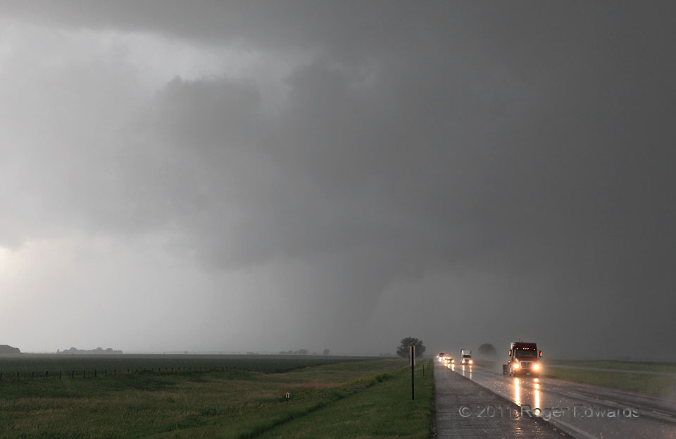
We already had seen several tornadoes with a separate, bizarre, midday to early-afternoon supercell near the center of a deep-layer cyclone, well west-southwest of here.  After that storm died, I knew that some young convective towers, visible on the dryline far to our east, could grow into supercells.  We also had an unusual but reasonable chance to intercept the “second-phase” event via I-80—a fortuitously placed and legally fast way to get there.  As we headed east, a squall line formed from those towers, then evolved into a pearl necklace of somewhat connected supercells.  We shot a relative gap in the line, one that was filling thanks to an expanding supercell’s front-flank core.  Several minutes after we cleared the storm, this became visible in a rear-view mirror, a few miles south of I-80 and moving northward.  In the time it took to pull over into the grass and call in the report, the rain-wrapped “Hampton” tornado grew into this tapered-barrel shape, clearly endangering motorists on the Interstate.  The annals of tornado history are profusely littered with stories of folks driving into tornadoes they couldn’t see.  Fortunately, my fears here weren’t realized.  A tornado watch was out, warnings from NWS Hastings were timely and well-broadcast for those driving with local radio turned on, and the tornado itself was just visible enough for drivers to avoid.  This version of the photo, as my usual custom, is only enhanced to natural viewing level (how I viewed it, and how you likely would see it).

3 NW Henderson NE (20 Jun 11) Looking W
40.8207, -97.8498

RADAR

Filed Under: Tornadoes Tagged With: clouds, convection, Great Plains, Hampton, Henderson, highways, landscapes, Nebraska, rain, storms, supercells, thunderstorms, tornado, weather

Previous: First Alma Nocturnal
Next: Shaw Lake Reflections

About

Welcome to SkyPix, an online photo book of clouds, weather and water by Roger Edwards. As in a printed coffee-table book, every image has its own page with a unique story. After all, meaningful photography is much more than just picture-taking; it is visually rendering a moment in place and time from a perspective like none other. As a scientist and an artist, I hope my deep passion for the power and splendor of our skies and waters shines through in these pages. If you are a cloud and weather aficionado, outdoor enthusiast, outdoor or nature photographer, art lover, or anyone who craves learning, enjoy...

More

Further images from this photographer may be found at:
Roger Edwards Image of the Week
Roger Edwards Digital Galleries
Storms Observed Chase BLOG

Copyright © 2025 ROGER EDWARDS SKYPIX.PHOTOGRAPHY ALL RIGHTS RESERVED. · Design by INSOJOURN Design and Images · WordPress · Log in