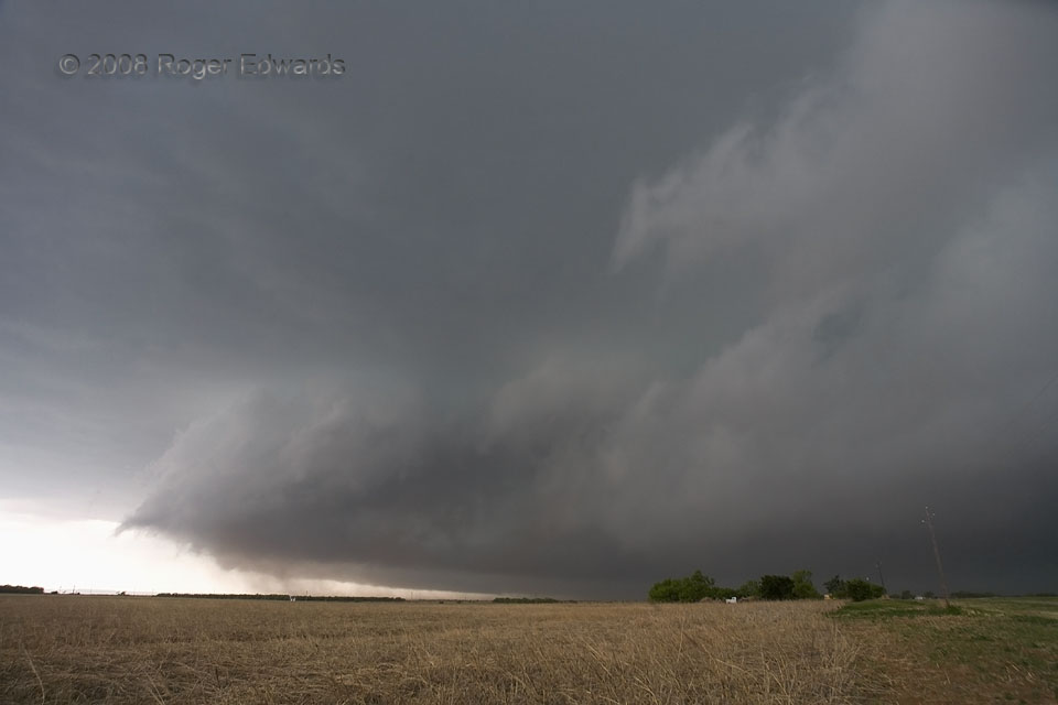
 A ragged shelf cloud formed atop the gust front from a heavy-precipitation (HP) supercell in NW Texas—one of many dark, menacing, mercilessly severe, HP storms I’ve intercepted over the years, in the general corridor surrounded by Dallas, Wichita Falls, San Angelo and Stephenville. The cumuliform character of the clouds atop the left edge of the shelf indicates the cloud base was convective in nature, despite riding cold outflow. The dust rising to cloud base was kicked up by the outflow then lifted into that interface. Even though the mesocyclone was elevated over the storm’s own outflow puddle at the surface, that didn’t stop it from merging with another supercell and raging onward across several counties from Jones eastward, cranking out hail up to baseball size and a swath of damaging wind. After this photo, it took all the navigational tactics and savvy we could muster just to get out of the way of the onrushing, vaporous beast, or risk being munched and swallowed whole into the dangerous murk. Fortunately this didn’t end the chase day! We went a couple hours further toward the dryline to observe another supercell also produce photogenic outflow, and ultimately, a wonderful sunset.
1 WSW Noodle TX (23 Apr 8) Looking WSW
32.5981, -100.07
A ragged shelf cloud formed atop the gust front from a heavy-precipitation (HP) supercell in NW Texas—one of many dark, menacing, mercilessly severe, HP storms I’ve intercepted over the years, in the general corridor surrounded by Dallas, Wichita Falls, San Angelo and Stephenville. The cumuliform character of the clouds atop the left edge of the shelf indicates the cloud base was convective in nature, despite riding cold outflow. The dust rising to cloud base was kicked up by the outflow then lifted into that interface. Even though the mesocyclone was elevated over the storm’s own outflow puddle at the surface, that didn’t stop it from merging with another supercell and raging onward across several counties from Jones eastward, cranking out hail up to baseball size and a swath of damaging wind. After this photo, it took all the navigational tactics and savvy we could muster just to get out of the way of the onrushing, vaporous beast, or risk being munched and swallowed whole into the dangerous murk. Fortunately this didn’t end the chase day! We went a couple hours further toward the dryline to observe another supercell also produce photogenic outflow, and ultimately, a wonderful sunset.
1 WSW Noodle TX (23 Apr 8) Looking WSW
32.5981, -100.07HP Menace
 A ragged shelf cloud formed atop the gust front from a heavy-precipitation (HP) supercell in NW Texas—one of many dark, menacing, mercilessly severe, HP storms I’ve intercepted over the years, in the general corridor surrounded by Dallas, Wichita Falls, San Angelo and Stephenville. The cumuliform character of the clouds atop the left edge of the shelf indicates the cloud base was convective in nature, despite riding cold outflow. The dust rising to cloud base was kicked up by the outflow then lifted into that interface. Even though the mesocyclone was elevated over the storm’s own outflow puddle at the surface, that didn’t stop it from merging with another supercell and raging onward across several counties from Jones eastward, cranking out hail up to baseball size and a swath of damaging wind. After this photo, it took all the navigational tactics and savvy we could muster just to get out of the way of the onrushing, vaporous beast, or risk being munched and swallowed whole into the dangerous murk. Fortunately this didn’t end the chase day! We went a couple hours further toward the dryline to observe another supercell also produce photogenic outflow, and ultimately, a wonderful sunset.
1 WSW Noodle TX (23 Apr 8) Looking WSW
32.5981, -100.07