SkyPix

A digital photographic storybook of clouds, weather and water by Roger Edwards.

  • Home
  • Newest Posts
  • Galleries
    • Aerial
    • All Hail
    • Burnscapes
    • Daytime Lightning
    • Floods
    • Fog and Mist
    • Gallery of Outflow
    • Hurricane Andrew
    • Mini Cloud Atlas
    • Night Lightning
    • Mostly Okie Winters
    • Sunsets and Sunrises
    • The Majestic Supercell
    • Tornadoes
    • Unusual Weather Damage
    • Visual Effects
    • Wall Cloud Wall
    • Water Works
  • About
  • F.A.Q.
  • Contact

Hart Wasn’t In It

2021-03-18 By Roger Edwards

Hart Wasn't In It

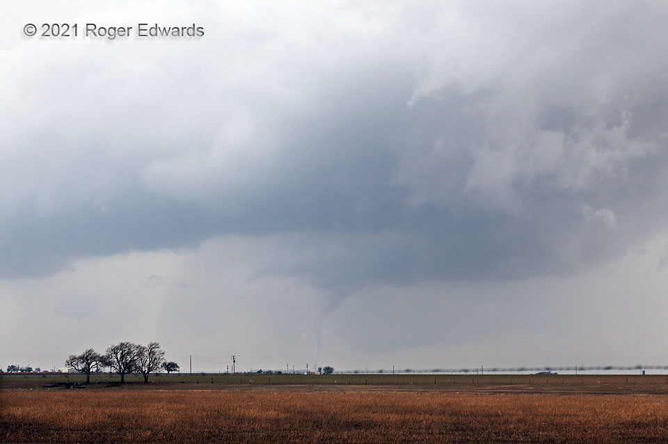
Every year, unique moments in storm observing present themselves, but this was on a different level.  As the clear slot cut around the mesocyclone of this small but tornadic supercell, and it emerged from even murkier haze to the southwest, I could spot a narrow cone with ground contact.  This was the “Hart tornado”, which came close to a West Texas Mesonet station at the time the site recorded an 87-mph gust.  A small, distant, low-contrast tornado—yes, been there, seen that.  The dilemma:  there was no hope to get closer for a better view.  I had to stay right there, settling for this perspective.  That’s because my vehicle had been stuck for half an hour in a muddy V-shaped ditch due to a simple, clumsy reversal error on my part.   I had spent much of the intervening time digging hundreds of pounds of mud and dirt off the roadside to make the slope more shallow in ultimately futile hope of unaided egress.  The irony?  This wasn’t even the supercell I was trying to observe when parking.  The earlier storm in the chain was much closer, with a disorganized mesocyclone passing just a mile or two to the west.  With both me and vehicle coated in mud, my reaction was less one of surprise or excitement than, “Oh, looky there, it’s producing.  Guess I could use a quick break.  I’ll try to shoot it, I suppose.”   Then right after it dissipated, I was right back to digging.

8 ESE Nazareth TX (13 Mar 21) Looking WSW
34.5284, -101.9553

RADAR


Filed Under: Tornadoes Tagged With: clouds, convection, Great Plains, Hart, landscapes, Nazareth, storms, supercells, Texas, Texas Panhandle, thunderstorms, tornado, weather

Previous: High Ice
Next: Hart Supercell and Tornado

About

Welcome to SkyPix, an online photo book of clouds, weather and water by Roger Edwards. As in a printed coffee-table book, every image has its own page with a unique story. After all, meaningful photography is much more than just picture-taking; it is visually rendering a moment in place and time from a perspective like none other. As a scientist and an artist, I hope my deep passion for the power and splendor of our skies and waters shines through in these pages. If you are a cloud and weather aficionado, outdoor enthusiast, outdoor or nature photographer, art lover, or anyone who craves learning, enjoy...

More

Further images from this photographer may be found at:
Roger Edwards Image of the Week
Roger Edwards Digital Galleries
Storms Observed Chase BLOG

Copyright © 2025 ROGER EDWARDS SKYPIX.PHOTOGRAPHY ALL RIGHTS RESERVED. · Design by INSOJOURN Design and Images · WordPress · Log in