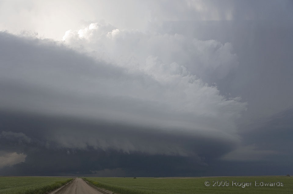
 After producing one tornado in Wyoming and very nearly another in the Nebraska Panhandle, this storm settled down somewhat to “just” a menacing convective mass of wind, rain and hail, wrapped within a fascinating sweep of curves and lines in its cloud package. Many processes were at work here! The thick, striated bands sweeping outward from the storm formed in layers of laminar, rising flow atop its rear-flank gust front. Beneath the cloud base, the newer mesocyclone sported a ragged, precip-filled wall cloud at right, while an older, occluded and secluded circulation wound down amidst a large but weakly rotating wall cloud down the road. Across the top right of the frame, a nearly horizontal shadow sliced the sky, cast by deep convective towers that faced the very late afternoon sun. Meanwhile, tail clouds at lower right fed into the east and southeast sides of the supercell.
3 ENE Gurley NE (5 Jun 9) Looking N
41.33, -102.9157
After producing one tornado in Wyoming and very nearly another in the Nebraska Panhandle, this storm settled down somewhat to “just” a menacing convective mass of wind, rain and hail, wrapped within a fascinating sweep of curves and lines in its cloud package. Many processes were at work here! The thick, striated bands sweeping outward from the storm formed in layers of laminar, rising flow atop its rear-flank gust front. Beneath the cloud base, the newer mesocyclone sported a ragged, precip-filled wall cloud at right, while an older, occluded and secluded circulation wound down amidst a large but weakly rotating wall cloud down the road. Across the top right of the frame, a nearly horizontal shadow sliced the sky, cast by deep convective towers that faced the very late afternoon sun. Meanwhile, tail clouds at lower right fed into the east and southeast sides of the supercell.
3 ENE Gurley NE (5 Jun 9) Looking N
41.33, -102.9157Gurley Swirl
 After producing one tornado in Wyoming and very nearly another in the Nebraska Panhandle, this storm settled down somewhat to “just” a menacing convective mass of wind, rain and hail, wrapped within a fascinating sweep of curves and lines in its cloud package. Many processes were at work here! The thick, striated bands sweeping outward from the storm formed in layers of laminar, rising flow atop its rear-flank gust front. Beneath the cloud base, the newer mesocyclone sported a ragged, precip-filled wall cloud at right, while an older, occluded and secluded circulation wound down amidst a large but weakly rotating wall cloud down the road. Across the top right of the frame, a nearly horizontal shadow sliced the sky, cast by deep convective towers that faced the very late afternoon sun. Meanwhile, tail clouds at lower right fed into the east and southeast sides of the supercell.
3 ENE Gurley NE (5 Jun 9) Looking N
41.33, -102.9157