 Once a series of tornadoes I observed near the Wichita Mountains dissipated, a residual mesocyclone cruised NE. Projecting to stay just ahead of its track in a zigzag route, I headed E then N, fully expecting an Oklahoma rendition of the “gales of November” to ensue in the inflow (hey, it was November!). Only the old circulation that it would have been immediately to my W vanished in little more than a finger snap. Rain curtains moved in different non-cyclonic directions on all sides, turbulent, but with a brief interlude of little to no wind. After fleeting concern, I looked up at the southward-moving clouds and around at the accelerating north wind to my E, and realized: I was temporarily in a harmless col (saddle point) in the surface flow, and a new circulation must be cycling up to my right (east or southeast). A tornado wouldn’t threaten me in that position, but bigtime hail could! The storm was “jumping mesos” past me. After I turned E, but carefully and not too far, this small but entertaining vortex formed in an unusual direction of view. Being WNW of the tornado, in inner rim of the back-side hook echo, is not an ideal vantage in most instances. I don’t recommend it. Fortunately this particular hook contained mostly heavy rain. Only sporadic large hailstones fell, one in the field making that splash to the tornado’s front left, no impacts on the vehicle or your increasingly rain-soaked tornado photographer. This fuzzy cone only lasted a few minutes and stayed over open land; but I still had to let its weakening remnant cross the road to my E before safe egress from the mesocyclone area.
3 N Alden OK (7 Nov 11) Looking ESE
35.0134, -98.5854
RADAR
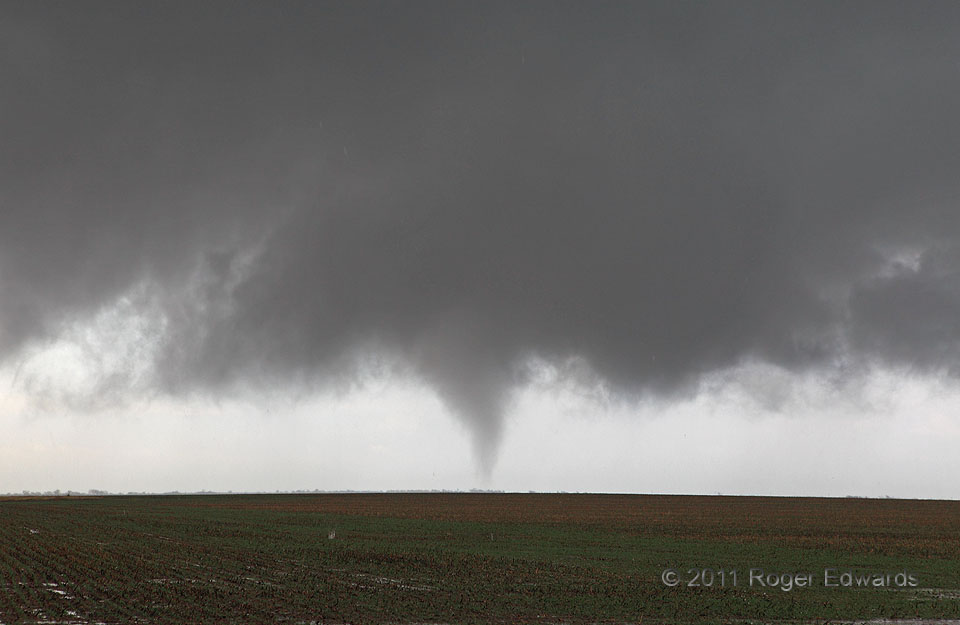
Once a series of tornadoes I observed near the Wichita Mountains dissipated, a residual mesocyclone cruised NE. Projecting to stay just ahead of its track in a zigzag route, I headed E then N, fully expecting an Oklahoma rendition of the “gales of November” to ensue in the inflow (hey, it was November!). Only the old circulation that it would have been immediately to my W vanished in little more than a finger snap. Rain curtains moved in different non-cyclonic directions on all sides, turbulent, but with a brief interlude of little to no wind. After fleeting concern, I looked up at the southward-moving clouds and around at the accelerating north wind to my E, and realized: I was temporarily in a harmless col (saddle point) in the surface flow, and a new circulation must be cycling up to my right (east or southeast). A tornado wouldn’t threaten me in that position, but bigtime hail could! The storm was “jumping mesos” past me. After I turned E, but carefully and not too far, this small but entertaining vortex formed in an unusual direction of view. Being WNW of the tornado, in inner rim of the back-side hook echo, is not an ideal vantage in most instances. I don’t recommend it. Fortunately this particular hook contained mostly heavy rain. Only sporadic large hailstones fell, one in the field making that splash to the tornado’s front left, no impacts on the vehicle or your increasingly rain-soaked tornado photographer. This fuzzy cone only lasted a few minutes and stayed over open land; but I still had to let its weakening remnant cross the road to my E before safe egress from the mesocyclone area.
3 N Alden OK (7 Nov 11) Looking ESE
35.0134, -98.5854
RADARFuzzy Cone
Once a series of tornadoes I observed near the Wichita Mountains dissipated, a residual mesocyclone cruised NE. Projecting to stay just ahead of its track in a zigzag route, I headed E then N, fully expecting an Oklahoma rendition of the “gales of November” to ensue in the inflow (hey, it was November!). Only the old circulation that it would have been immediately to my W vanished in little more than a finger snap. Rain curtains moved in different non-cyclonic directions on all sides, turbulent, but with a brief interlude of little to no wind. After fleeting concern, I looked up at the southward-moving clouds and around at the accelerating north wind to my E, and realized: I was temporarily in a harmless col (saddle point) in the surface flow, and a new circulation must be cycling up to my right (east or southeast). A tornado wouldn’t threaten me in that position, but bigtime hail could! The storm was “jumping mesos” past me. After I turned E, but carefully and not too far, this small but entertaining vortex formed in an unusual direction of view. Being WNW of the tornado, in inner rim of the back-side hook echo, is not an ideal vantage in most instances. I don’t recommend it. Fortunately this particular hook contained mostly heavy rain. Only sporadic large hailstones fell, one in the field making that splash to the tornado’s front left, no impacts on the vehicle or your increasingly rain-soaked tornado photographer. This fuzzy cone only lasted a few minutes and stayed over open land; but I still had to let its weakening remnant cross the road to my E before safe egress from the mesocyclone area.
3 N Alden OK (7 Nov 11) Looking ESE
35.0134, -98.5854
RADAR