 Also known as “hole punch cloud”, this cloud type is defined more by cloud absence. Most are circular, elliptical, or cigar-shaped, but this one appears like a dinosaur foot, loosely akin in shape to a bizarre supercell base I photographed in 2011. Fallstreak holes can have many origins, but usually happen when airplanes introduce ice crystals two ways within a field of cirrocumulus (or dense altocumulus) clouds: 1) directly through freezing of water vapor in the exhaust and 2) fast cooling of cloud material through mechanically forced, aerodynamic pressure drop around the aircraft. The clouds previously had supercooled water droplets (below freezing temperature, but not yet frozen due to absence of particle nuclei). Once cooled enough to freeze, the ice crystals rob liquid water from surrounding cloud material and fall away, leaving a hole. Often, as here, a bright, icy cloud forms inside, dropping snowy fallstreaks. This production of ice crystals at the expense of water droplets is related to the different vapor pressures of water and ice, and has been noticed around areas of hoarfrost formation in trees for over 100 years. It is known as the “Bergeron process” because meteorologist Tor Bergeron presented the concept in a 1933 conference paper, though Alfred Wegener theorized it 22 years earlier.
Norman OK (2 Jan 20) Looking NE
Also known as “hole punch cloud”, this cloud type is defined more by cloud absence. Most are circular, elliptical, or cigar-shaped, but this one appears like a dinosaur foot, loosely akin in shape to a bizarre supercell base I photographed in 2011. Fallstreak holes can have many origins, but usually happen when airplanes introduce ice crystals two ways within a field of cirrocumulus (or dense altocumulus) clouds: 1) directly through freezing of water vapor in the exhaust and 2) fast cooling of cloud material through mechanically forced, aerodynamic pressure drop around the aircraft. The clouds previously had supercooled water droplets (below freezing temperature, but not yet frozen due to absence of particle nuclei). Once cooled enough to freeze, the ice crystals rob liquid water from surrounding cloud material and fall away, leaving a hole. Often, as here, a bright, icy cloud forms inside, dropping snowy fallstreaks. This production of ice crystals at the expense of water droplets is related to the different vapor pressures of water and ice, and has been noticed around areas of hoarfrost formation in trees for over 100 years. It is known as the “Bergeron process” because meteorologist Tor Bergeron presented the concept in a 1933 conference paper, though Alfred Wegener theorized it 22 years earlier.
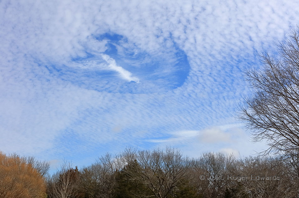
Norman OK (2 Jan 20) Looking NEFallstreak Hole (Cavum) in Cirrocumulus
Also known as “hole punch cloud”, this cloud type is defined more by cloud absence. Most are circular, elliptical, or cigar-shaped, but this one appears like a dinosaur foot, loosely akin in shape to a bizarre supercell base I photographed in 2011. Fallstreak holes can have many origins, but usually happen when airplanes introduce ice crystals two ways within a field of cirrocumulus (or dense altocumulus) clouds: 1) directly through freezing of water vapor in the exhaust and 2) fast cooling of cloud material through mechanically forced, aerodynamic pressure drop around the aircraft. The clouds previously had supercooled water droplets (below freezing temperature, but not yet frozen due to absence of particle nuclei). Once cooled enough to freeze, the ice crystals rob liquid water from surrounding cloud material and fall away, leaving a hole. Often, as here, a bright, icy cloud forms inside, dropping snowy fallstreaks. This production of ice crystals at the expense of water droplets is related to the different vapor pressures of water and ice, and has been noticed around areas of hoarfrost formation in trees for over 100 years. It is known as the “Bergeron process” because meteorologist Tor Bergeron presented the concept in a 1933 conference paper, though Alfred Wegener theorized it 22 years earlier.
Norman OK (2 Jan 20) Looking NE