SkyPix

A digital photographic storybook of clouds, weather and water by Roger Edwards.

  • Home
  • Newest Posts
  • Galleries
    • Aerial
    • All Hail
    • Burnscapes
    • Daytime Lightning
    • Floods
    • Fog and Mist
    • Gallery of Outflow
    • Hurricane Andrew
    • Mini Cloud Atlas
    • Night Lightning
    • Mostly Okie Winters
    • Sunsets and Sunrises
    • The Majestic Supercell
    • Tornadoes
    • Unusual Weather Damage
    • Visual Effects
    • Wall Cloud Wall
    • Water Works
  • About
  • F.A.Q.
  • Contact

Elevated Supercell

2015-02-17 By Roger Edwards

Elevated Supercell

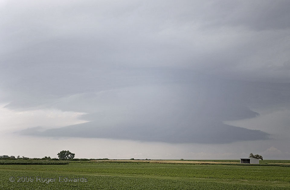
Operational meteorologists consider a thunderstorm “elevated” if its inflow is not directly rooted at the surface.  In other words, the storm is tapping a plume of moist and unstable air above, not at ground level.  This usually happens atop a relatively cool, stable air mass, like one might find on the cold side of a front, behind an outflow boundary, or atop an inversion caused by strong nighttime cooling of the surface.  Elevated thunderstorms that develop that way aren’t often seen, usually because of intervening low clouds or rain common to such air masses.  This photo, therefore, offers quite an uncommonly clean look at a newly formed, elevated supercell.  Somewhat starved for buoyant air, its banded, plated features looked fairly characteristic of a surface-based supercell whose inflow experiences forced lifting, but softer and more diffused.  This storm, occurring before solar noon, drew its inflow from north of a warm front, in an air mass of favorable deep-layer shear.  It would move eastward across northern Kansas, and eventually cross the warm front into strongly heated, very moist and surface-based air, producing a brief tornado.

2 WSW Belleville KS (17 Jun 9) Looking NW
39.8129, -97.6708

Filed Under: The Majestic Supercell Tagged With: Belleville, clouds, Great Plains, Kansas, landscapes, storms, supercells, thunderstorms, weather

Previous: Sunlit Spray Cloud: Dettifoss
Next: Scud Rags

About

Welcome to SkyPix, an online photo book of clouds, weather and water by Roger Edwards. As in a printed coffee-table book, every image has its own page with a unique story. After all, meaningful photography is much more than just picture-taking; it is visually rendering a moment in place and time from a perspective like none other. As a scientist and an artist, I hope my deep passion for the power and splendor of our skies and waters shines through in these pages. If you are a cloud and weather aficionado, outdoor enthusiast, outdoor or nature photographer, art lover, or anyone who craves learning, enjoy...

More

Further images from this photographer may be found at:
Roger Edwards Image of the Week
Roger Edwards Digital Galleries
Storms Observed Chase BLOG

Copyright © 2025 ROGER EDWARDS SKYPIX.PHOTOGRAPHY ALL RIGHTS RESERVED. · Design by INSOJOURN Design and Images · WordPress · Log in