SkyPix

A digital photographic storybook of clouds, weather and water by Roger Edwards.

  • Home
  • Newest Posts
  • Galleries
    • Aerial
    • All Hail
    • Burnscapes
    • Daytime Lightning
    • Floods
    • Fog and Mist
    • Gallery of Outflow
    • Hurricane Andrew
    • Mini Cloud Atlas
    • Night Lightning
    • Mostly Okie Winters
    • Sunsets and Sunrises
    • The Majestic Supercell
    • Tornadoes
    • Unusual Weather Damage
    • Visual Effects
    • Wall Cloud Wall
    • Water Works
  • About
  • F.A.Q.
  • Contact

Early Mulhall Tornado

2019-01-25 By Roger Edwards

Early Mulhall Tornado

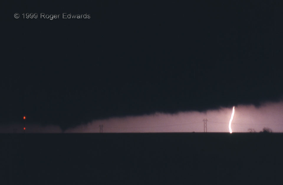
“Early” in the title refers to the stage of this tornado, not the hour. We just had finished viewing the dying stages of the “Cashion” tornado to our northwest in faint lightning and artificial light, suspected a new cyclic mesocyclone was forming to our northeast, and rapidly received this confirmation! The Crescent/Mulhall tornado was the 18th spawned by the “Storm B” supercell alone, and the 11th and last we observed on this astounding outbreak day. The condensation cone just had developed to the northeast within the preceding minute or less—barely enough time to set up my tripod and camera for this, the only film-slide photograph I was able to get of the tornado. In fact, I know of no other actual photographs of it (as opposed to video frames). The fortuitous cloud-to-ground stroke occurred from the flanking line of the new mesocyclone. All other lightning we saw was fainter, buried in heavy precip to the tornado’s northeast or north. Within seconds, the visible vortex assumed wedge shape, growing to half a mile wide (based on damage survey). As we zigzagged northeastward to keep up, it would swell to well over a mile across, with F4 damage on the north (weaker!) side of the tornado, and mobile-radar-detected subvortices larger than the quarter-mile-wide Spencer, SD, F4 tornado that I had seen the year before.

1 E Cashion OK (3 May 99) Looking NE
35.8006, -97.6565

RADAR

Filed Under: Night Lightning, Tornadoes Tagged With: Cashion, clouds, convection, lightning, Mulhall, nighttime, Oklahoma, storms, supercells, thunderstorms, tornado, weather

Previous: Cumulus Mediocris over Fort Davis
Next: Bronzish Rain Light

About

Welcome to SkyPix, an online photo book of clouds, weather and water by Roger Edwards. As in a printed coffee-table book, every image has its own page with a unique story. After all, meaningful photography is much more than just picture-taking; it is visually rendering a moment in place and time from a perspective like none other. As a scientist and an artist, I hope my deep passion for the power and splendor of our skies and waters shines through in these pages. If you are a cloud and weather aficionado, outdoor enthusiast, outdoor or nature photographer, art lover, or anyone who craves learning, enjoy...

More

Further images from this photographer may be found at:
Roger Edwards Image of the Week
Roger Edwards Digital Galleries
Storms Observed Chase BLOG

Copyright © 2025 ROGER EDWARDS SKYPIX.PHOTOGRAPHY ALL RIGHTS RESERVED. · Design by INSOJOURN Design and Images · WordPress · Log in