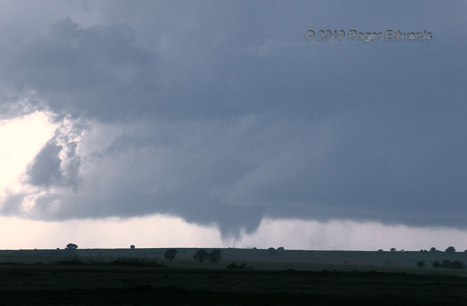
 After developing quickly into a conical shape, the Tipton (KS) tornado’s visual cloud form expanded, going through this rapidly evolving, tumultuous, multiple-vortex phase. This is a common evolution I’ve seen with longer-lived tornadoes in helicity-rich and high-humidity environments, such as the Dover/Kingfisher event from 2010 , the Minco tornado from 3 May 1999 (even faster-changing, shape-shifting in the span of seconds), and most recently to this, a nighttime tornado 11 days prior and about 150 miles away. Others start out as broad multivortex circulations and stay that way, such as the “Wind Farm Tornado” from 2011. One of the most fascinating and still somewhat mysterious aspects to tornadoes is their evolution (especially change in apparent size and shape), which likely depends on a mix of storm-scale and environmental factors at least as capricious as tornadogenesis itself. The fact that tornado morphologies sometimes resemble each other in similar environments does suggest the potential for predictability, which is promising. Though mobile mesonets, balloon sondes and drones from field projects have offered a few tantalizing clues to feed to numerical and conceptual models, we’re still far from consistently resolving fine-scale (less than a mile across and deep) observational airmass characteristics, across a large sample of tornadic supercells, that likely exert great influence on minute-by-minute tornado behavior.
1 S Glen Elder KS (28 May 19) Looking SW
39.4702, -98.3123
RADAR
After developing quickly into a conical shape, the Tipton (KS) tornado’s visual cloud form expanded, going through this rapidly evolving, tumultuous, multiple-vortex phase. This is a common evolution I’ve seen with longer-lived tornadoes in helicity-rich and high-humidity environments, such as the Dover/Kingfisher event from 2010 , the Minco tornado from 3 May 1999 (even faster-changing, shape-shifting in the span of seconds), and most recently to this, a nighttime tornado 11 days prior and about 150 miles away. Others start out as broad multivortex circulations and stay that way, such as the “Wind Farm Tornado” from 2011. One of the most fascinating and still somewhat mysterious aspects to tornadoes is their evolution (especially change in apparent size and shape), which likely depends on a mix of storm-scale and environmental factors at least as capricious as tornadogenesis itself. The fact that tornado morphologies sometimes resemble each other in similar environments does suggest the potential for predictability, which is promising. Though mobile mesonets, balloon sondes and drones from field projects have offered a few tantalizing clues to feed to numerical and conceptual models, we’re still far from consistently resolving fine-scale (less than a mile across and deep) observational airmass characteristics, across a large sample of tornadic supercells, that likely exert great influence on minute-by-minute tornado behavior.
1 S Glen Elder KS (28 May 19) Looking SW
39.4702, -98.3123
RADARDistant Multivortex
After developing quickly into a conical shape, the Tipton (KS) tornado’s visual cloud form expanded, going through this rapidly evolving, tumultuous, multiple-vortex phase. This is a common evolution I’ve seen with longer-lived tornadoes in helicity-rich and high-humidity environments, such as the Dover/Kingfisher event from 2010 , the Minco tornado from 3 May 1999 (even faster-changing, shape-shifting in the span of seconds), and most recently to this, a nighttime tornado 11 days prior and about 150 miles away. Others start out as broad multivortex circulations and stay that way, such as the “Wind Farm Tornado” from 2011. One of the most fascinating and still somewhat mysterious aspects to tornadoes is their evolution (especially change in apparent size and shape), which likely depends on a mix of storm-scale and environmental factors at least as capricious as tornadogenesis itself. The fact that tornado morphologies sometimes resemble each other in similar environments does suggest the potential for predictability, which is promising. Though mobile mesonets, balloon sondes and drones from field projects have offered a few tantalizing clues to feed to numerical and conceptual models, we’re still far from consistently resolving fine-scale (less than a mile across and deep) observational airmass characteristics, across a large sample of tornadic supercells, that likely exert great influence on minute-by-minute tornado behavior.
1 S Glen Elder KS (28 May 19) Looking SW
39.4702, -98.3123
RADAR