SkyPix

A digital photographic storybook of clouds, weather and water by Roger Edwards.

  • Home
  • Newest Posts
  • Galleries
    • Aerial
    • All Hail
    • Burnscapes
    • Daytime Lightning
    • Floods
    • Fog and Mist
    • Gallery of Outflow
    • Hurricane Andrew
    • Mini Cloud Atlas
    • Night Lightning
    • Mostly Okie Winters
    • Sunsets and Sunrises
    • The Majestic Supercell
    • Tornadoes
    • Unusual Weather Damage
    • Visual Effects
    • Wall Cloud Wall
    • Water Works
  • About
  • F.A.Q.
  • Contact

Derecho across the Badlands

2020-06-14 By Roger Edwards

Derecho across the Badlands

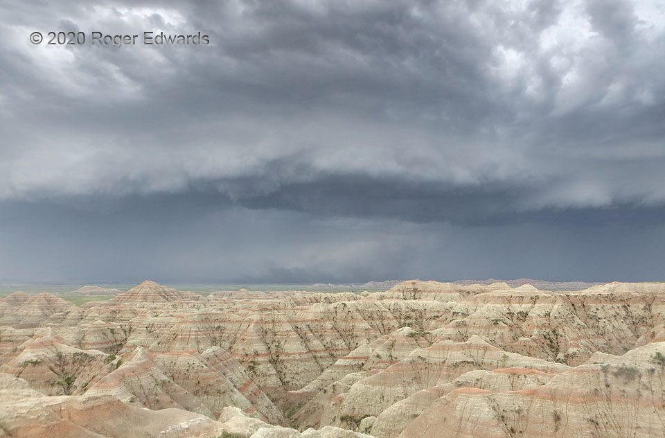
[Part 1 of 2]  Aside from being set in wondrously scenic geology, this image now stands as a piece of major weather history.  Earlier in the afternoon, I had been positioned in western South Dakota, north of Sturgis, in the event any supercells could develop ahead of a line of thunderstorms that yielded severe wind in the central Rockies for hours.  A 110-mph gust report buzzed off the weather wire from Winter Park, CO, so I knew the expansive storm complex meant serious business.   With discrete-supercell potential diminishing, and knowing a phenomenal wall of wind was approaching from Wyoming, I wheeled southeast and set up on a high Badlands ridge for observation and photography of its approach.  With over half an hour to spare, I parked nearby and pointed southwest toward the oncoming blast, deliberately located where no upstream debris could be generated, except small vegetation pieces, dirt and grit.   I could dart back in less than a minute, and soon would need to!  From a safe distance, I also warned several tourists that a very severe windstorm was coming, and they needed to find shelter.  The downburst beginning across the basin, at lower middle, was part of a slowly rotating, line-embedded vortex.  The dust “below” it was in the circulation’s downdraft, which was fanning out left on the left side, toward me in the middle, and to the right on the right side.  The dust never tightened into a closed circulation at ground level.  Note the clearing behind it compared to the precip cores either side.  The feature would hit just a couple minutes later, embedded in convective system itself traveling around 60 mph.  [Go to Part 2]

4 NW Interior SD (6 Jun 20) Looking SW
43.7883, -102.0323

Filed Under: Gallery of Outflow Tagged With: arcus, Badlands, clouds, convection, dust, geology, Great Plains, Interior, landscapes, National Parks, outflow, shelf cloud, South Dakota, storms, thunderstorms, weather

Previous: Blue Hour in the Badlands
Next: Three-State Supercell

About

Welcome to SkyPix, an online photo book of clouds, weather and water by Roger Edwards. As in a printed coffee-table book, every image has its own page with a unique story. After all, meaningful photography is much more than just picture-taking; it is visually rendering a moment in place and time from a perspective like none other. As a scientist and an artist, I hope my deep passion for the power and splendor of our skies and waters shines through in these pages. If you are a cloud and weather aficionado, outdoor enthusiast, outdoor or nature photographer, art lover, or anyone who craves learning, enjoy...

More

Further images from this photographer may be found at:
Roger Edwards Image of the Week
Roger Edwards Digital Galleries
Storms Observed Chase BLOG

Copyright © 2025 ROGER EDWARDS SKYPIX.PHOTOGRAPHY ALL RIGHTS RESERVED. · Design by INSOJOURN Design and Images · WordPress · Log in